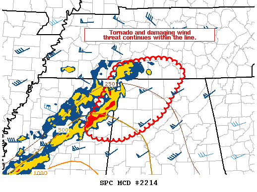
Mesoscale Discussion Shows Severe Threat Continues

The severe weather threat for Tornado Watch 702 continues.
SUMMARY…The threat of tornadoes and damaging winds continues through the evening.
DISCUSSION…A mature bowing segment with a comma-head type feature is crossing from Northeast Mississippi into northwest Alabama at 2230Z. This feature has numerous areas of rotation with at least one TDS observed. In addition, some embedded supercells with strong rotation are apparent north and south of this feature along the line. Expect the damaging wind/tornado threat to continue into the evening through at least northwest Alabama. There is considerably more uncertainty in northeast Alabama where instability is currently limited with dewpoints in the upper 50s. Some northward transport of the better dewpoints and additional destabilization may occur over the next few hours. This limited instability may reduce the overall tornado threat once the line reaches northeast Alabama, but the low-level jet will also be strengthening over the next 2 to 4 hours which may sustain a threat farther east than the marginal instability would otherwise suggest.
Category: Alabama's Weather, ALL POSTS, Severe Weather


