Latest Mesoscale Precipitation Discussion From The WPC

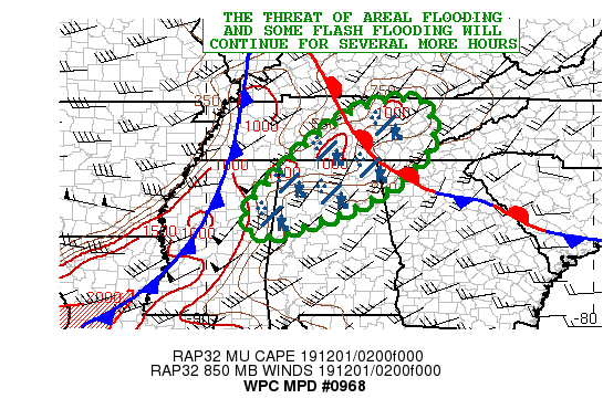
SUMMARY: Bands of heavy showers and thunderstorms will continue to foster concerns for areal flooding and some flash flooding going through the overnight hours.
DISCUSSION: The latest radar imagery shows an expansive area of heavy showers and thunderstorms impacting areas of central/northeast MS, northern AL, and south-central TN. The convection is focusing along and ahead of a cold front approaching the TN Valley and is associated with a deep layer trough advancing east across the Midwest.
Much of the convection is embedded within highly diffluent flow aloft and is coincident with a southwest low-level jet of 40 to 50 kts. The low-level jet is enhancing moisture transport up from the central Gulf Coast region, with PWs of 1.6 to 1.8 inches and this coupled with a nose of 500 to 1000 j/kg of MUCAPE is leading to relatively efficient bands of showers and thunderstorms. Some rainfall rates have occasionally been upwards of 1 to 1.5 inches/hr, and this coupled with a tendency for some repeating cell activity over the same area has already led to areas of flash flooding.
Additional heavy rainfall is expected to impact areas of northeast MS, northern AL, central/southern TN, and at least clipping areas of far northwest GA going through the overnight hours as the upstream cold front gradually approaches. The instability parameters will tend to wane somewhat, but there should still be sufficient large scale forcing and moisture transport for locally enhanced rainfall rates.
Expect as much as an additional 2 to 3 inches of rain going through 3:00 am, and this will likely result in at least a likelihood of some areal flooding, but where the rainfall rates exceed 1 inch/hr, some flash flooding can be expected as well. This will especially be the case across areas of northern AL where some flash flooding is already ongoing.
Category: Alabama's Weather, ALL POSTS, Severe Weather


