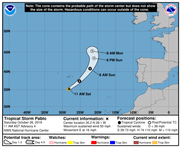
Pablo Slightly Stronger, Expected To Pass Near Or Over The Eastern Azores Tonight

SUMMARY OF 1100 AM AST…1500 UTC…INFORMATION
———————————————–
LOCATION…35.2N 28.1W
ABOUT 205 MI…325 KM SSW OF THE AZORES
MAXIMUM SUSTAINED WINDS…50 MPH…85 KM/H
PRESENT MOVEMENT…E OR 90 DEGREES AT 16 MPH…26 KM/H
MINIMUM CENTRAL PRESSURE…989 MB…29.21 INCHES
WATCHES AND WARNINGS
——————–
There are no coastal watches or warnings in effect.
DISCUSSION AND OUTLOOK
———————-
At 1100 AM AST (1500 UTC), the center of Tropical Storm Pablo was located near latitude 35.2 North, longitude 28.1 West. Pablo is moving toward the east near 16 mph (26 km/h). A turn toward the northeast with an increase in forward speed is expected later today, followed by a turn toward the north-northeast and north on Sunday. On the forecast track, the small core of Pablo will pass near or over the eastern Azores tonight.
Recent satellite wind data indicate that maximum sustained winds are now near 50 mph (85 km/h) with higher gusts. No significant change in strength is anticipated, and Pablo is expected to become an extratropical cyclone on Sunday or Sunday night.
Tropical-storm-force winds extend outward up to 45 miles (75 km) from the center.
The estimated minimum central pressure is 989 mb (29.21 inches).
HAZARDS AFFECTING LAND
———————-
Since Pablo is embedded within a large extratropical low, which itself is forecast to bring strong winds to the Azores, the Portuguese Institute for the Sea and Atmosphere (IPMA) has included the effects of this small cyclone in their products. Those products already account for the strong winds and high waves.


