PTC-16 Not Expected To Become A Tropical/Subtropical Storm Until Friday

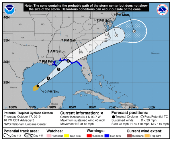
SUMMARY OF 1000 PM CDT INFORMATION
LOCATION…24.1N 93.7W
ABOUT 445 MI…720 KM SW OF THE MOUTH OF THE MISSISSIPPI RIVER
MAXIMUM SUSTAINED WINDS…40 MPH…65 KM/H
PRESENT MOVEMENT…NE OR 45 DEGREES AT 12 MPH…19 KM/H
MINIMUM CENTRAL PRESSURE…1004 MB…29.65 INCHES
SUMMARY OF WATCHES AND WARNINGS IN EFFECT
A Tropical Storm Warning is in effect for…
* Mississippi/Alabama border to Yankeetown Florida
* Grand Isle Louisiana to the Mouth of the Pearl River
A Storm Surge Warning is in effect for…
* Indian Pass Florida to Clearwater Beach Florida

The disturbance over the southwestern Gulf of Mexico continues to produce a large area of cloudiness and thunderstorms over much of the central and southwestern Gulf of Mexico. The system is not yet a tropical or subtropical cyclone as it still lacks sufficient convective organization and an Air Force reconnaissance aircraft that flew into the disturbance late this afternoon found a broad circulation, but no evidence of a well-defined center. The global models indicate that the circulation will become better defined by early Friday, and that the low will deepen within an area of strong upper-level divergence to the east of an upper-level trough over southeastern Texas. As a result, strengthening is forecast while the system moves over the Gulf of Mexico during the next 24 to 36 hours. While the system is unlikely to develop into a classical tropical cyclone, it is expected to obtain enough organized convection to become a tropical or subtropical cyclone on Friday or Friday night before is reaches the northern Gulf coast. After landfall, the cyclone is expected to become extratropical and gradually weaken while it moves northeastward near the southeast U.S. coast. By day 5, the low is forecast to be absorbed by a front over the western Atlantic.
The disturbance is moving northeastward at about 10 kt. The system should accelerate northeastward ahead of the aforementioned trough on Friday, and the northeastward motion should then continue during the next few days. The low is forecast to slow down and turn east-northeastward after 72 hours when the mid-level flow becomes more zonal. The new NHC track forecast uses a blend of the lastest global model fields and is very similar to the previous advisory.
Regardless of the exact evolution of the system, portions of the northern coast of the Gulf of Mexico will experience strong winds, locally heavy rains, and storm surge Friday and Saturday. Similar impacts are expected across portions of the Atlantic coast of the southeastern United States Saturday and Sunday.
KEY MESSAGES
1. There is a danger of life-threatening storm surge inundation of up to 5 feet above ground level beginning Friday along the Florida Gulf Coast from Indian Pass to Clearwater, where a Storm Surge Warning is in effect. Residents in these areas should follow advice given by local officials.
2. Tropical storm force winds are likely by Friday afternoon along portions of the central and eastern Gulf Coast, where tropical storm warnings are in effect. Regardless of the exact track and intensity of the system, these winds will cover a large area, especially east of the center.
3. Isolated flash flooding is possible along the central and eastern Gulf Coast, mainly Friday and Friday night. Since soils across the southeast are dry, the risk of flash flooding will be confined to the immediate coast where heavier rainfall is possible.
4. Wind and coastal flooding hazards along the U.S. East Coast will be covered by non-tropical watches and warnings issued by local NWS offices, since the system is expected to lose any tropical characteristics after it moves inland along the Gulf Coast.


