Hot Afternoons Continue; Eyes On The Gulf This Weekend
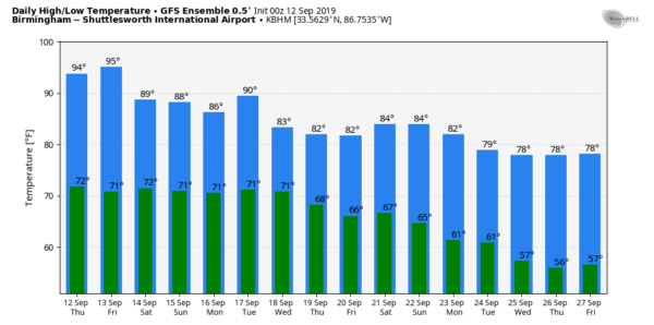
STILL HOT: A strong upper ridge is across the Southeast U.S… and that feature will keep Alabama unseasonably hot through tomorrow with highs in the mid 90s. The sky will be partly to mostly sunny, and any afternoon showers or thunderstorms should be few in number. The average high for September 12 at Birmingham is 86; the record high is 100 set in 1927.
SATURDAY AND BEYOND: We will bring in a chance of scattered showers and thunderstorms Saturday with a mix of sun and clouds. Odds of any one spot getting wet are about one in three, with most of showers coming during the afternoon and evening hours. The high Saturday will be in the 88-91 degree range.
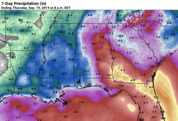
Then, Sunday and into early next week, our weather will be determined by the behavior of a tropical system that should be in the northeast Gulf of Mexico within 72 hours. This feature is now an open tropical wave over the Southeast Bahamas, and until a low level center is established, and we get dropsonde data into the models from reconnaissance aircraft, there will be great uncertainty. We will forecast an increased chance of rain for Alabama Sunday through Tuesday, and beneficial rain is very possible. But, the exact track of the tropical system will determine the amount of rain we see, and we aren’t totally sure we stay on the east, wet side of the system.
We will hold onto the chance of scattered showers and storms over the latter half of next week as a moist airmass remains in place… See the Weather Xtreme video for maps, graphics, and more details.
FOOTBALL WEATHER: The sky should be mostly clear for the high school games tomorrow night, with temperatures falling from the mid 80s at kickoff, to near 80 by the final whistle.
Saturday, Alabama travels to Columbia to take on South Carolina (2:30p CT kickoff)… the sky will be partly sunny with a kickoff temperature close to 90 degrees, then falling back slightly into the upper 80s by the fourth quarter. A few widely scattered showers are possible the region during the game.
Auburn hosts Kent State Saturday evening at Jordan-Hare Stadium (6:30p CT kickoff)… we can’t rule out the risk of a passing shower during the game, otherwise mostly fair with temperatures falling from around 88 at kickoff, into the low 80s by the game.
Jacksonville State has a home game Saturday against Eastern Washington (3:00p CT kickoff) a few scattered showers are possible over East Alabama during the game, otherwise expect a mix of sun and clouds with 89 degrees at kickoff, falling into the mid 80s by the fourth quarter.
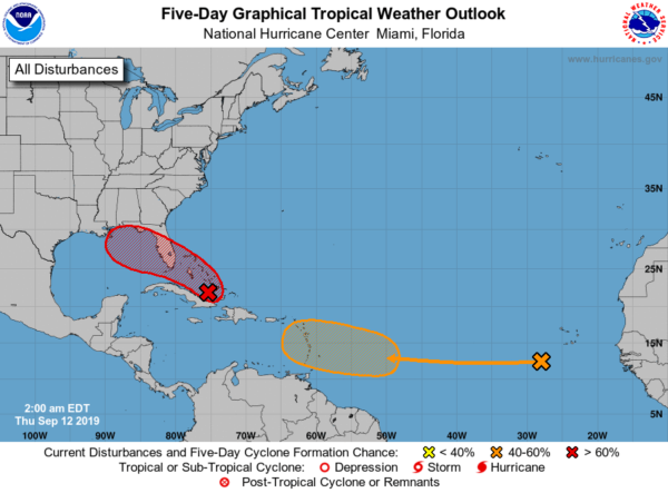
TROPICS: A tropical wave over the Atlantic between the coast of Africa and the Lesser Antilles has a medium chance of becoming a tropical depression or storm over the next five days; it is moving west and it remains to be seen if this will impact the Gulf of Mexico or the United States.
Invest 95L is over the Southeast Bahamas, and NHC gives it a high chance of becoming a tropical depression or storm by the weekend.
If it becomes a tropical storm, the name will be “Humberto”. Model data suggests this will not reach hurricane strength, but of course, that is not carved in stone. It has potential to bring beneficial rain to parts of the Southeast U.S. by Sunday and early next week, but it remains to be seen where the most widespread rain will fall.
The weather along the Gulf Coast over the weekend will be wet at times thanks to this system; expect periods of rain from Gulf Shores over to Destin and Panama City Beach Saturday and Sunday with dangerous rip currents likely. Weather conditions there should slowly improve by the middle of next week. But I stress it is simply too early to provide an impact forecast for any specific point.
ON THIS DATE IN 1979: Hurricane Frederic made landfall at about 10 p.m. CT, passing over Dauphin Island and crossed the coastline near the Alabama/Mississippi border. A wind gust of 145 miles per hour was measured on equipment atop the Dauphin Island Bridge. The bridge was destroyed. A wind gust of 139 mph was measured at the Dauphin Island Sea Lab before the equipment failed. A storm surge of 12 feet was observed in Gulf Shores. Nearly all structures within 200 yards of the Alabama coast were destroyed. There were only two fatalities as a direct result of Frederic. Total damages were 2.3 billion dollars, making Frederic the most expensive hurricane ever to strike the United States up to that point. Get more details from NWS Mobile here.
BEACH FORECAST: Click here to see the AlabamaWx Beach Forecast Center page.
WEATHER BRAINS: Don’t forget you can listen to our weekly 90 minute show anytime on your favorite podcast app. This is the show all about weather featuring many familiar voices, including our meteorologists here at ABC 33/40.
CONNECT: You can find me on all of the major social networks…
Facebook
Twitter
Instagram
Pinterest
Snapchat: spannwx
I have a weather program this morning at Westminster School at Oak Mountain… look for the next Weather Xtreme video here by 4:00 this afternoon. Enjoy the day!
Category: Alabama's Weather, ALL POSTS, Weather Xtreme Videos


