Sizzling September Weather Continues; Higher Rain Chances By Sunday
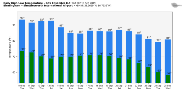
HOT SEPTEMBER WEATHER: Birmingham’s official high yesterday was 98 degrees; 11 degrees above average, but under the record high for September 9 (103 set in 1925). Anniston also recorded a high of 98, while Tuscaloosa and Gadsden topped out at 96 degrees. The weather won’t change much each day through the rest of the week as a strong upper ridge remains parked across the Deep South. Partly to mostly sunny days, fair nights, and only isolated afternoon and evening showers and thunderstorms. Odds of any one spot getting wet each day are in the 10-20 percent range. Afternoon highs will be generally in the mid 90s, with upper 90s in spots.
THE ALABAMA WEEKEND: The upper ridge begins to break down, heat levels drop, and rain chances will increase, especially by Sunday. The key feature in our rain potential will be a tropical wave, which is expected to be in the Gulf of Mexico. This wave will move up into the Southeast U.S., most likely, Sunday, and we will forecast occasional rain late in the weekend and into Monday of next week. This is a fairly low confidence forecast for now since a tropical system is involved. The high Saturday will be in the upper 80s, dropping into the low 80s Sunday.
REST OF NEXT WEEK: The weather for the mid-week period all depends on the behavior of the tropical system, but for now we will indicate a reduced chance of rain by Tuesday and Wednesday. Highs during the week should be in the 80s… See the Weather Xtreme video for maps, graphics, and more details.
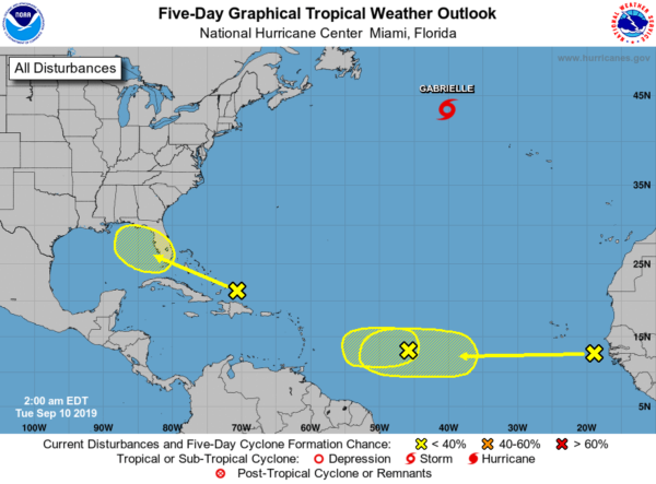
TROPICS: Tropical Storm Gabrielle in the North Atlantic will become post-tropical later today. There are two waves in the lower latitudes; one between the Lesser Antilles and the coast of Africa, and another one just coming off the African continent. Both of these are given only a low chance of development over the next five days by NHC.
A wave that is near the Bahamas is forecast to move across the Florida Peninsula and into the Gulf of Mexico this weekend. Again, for now, NHC gives it only a low chance of development over the next five days. This is the one that has potential to bring beneficial rain to parts of the Southeast U.S. by Sunday and Monday, including Alabama. Best chance scenario is for this feature to stay an open wave, but you always have to watch these carefully as SSTs (sea surface temperatures) in the Gulf of Mexico are still very warm.
ON THIS DATE IN 1960: The center of Hurricane Donna passed over the middle of the Florida Keys between 2, and 3 am on this day. Donna was a Category 5 hurricane over the Atlantic and a Category 4 at landfall. This storm caused the deaths of over 100 in Puerto Rico, 50 in the United States, and 63 in a jet crash. The plane crash occurred on August 29th as a French airliner was attempting to land at Dakar, Senegal during a “blinding rainstorm.” The storm was likely a tropical disturbance at the time of the crash.
BEACH FORECAST: Click here to see the AlabamaWx Beach Forecast Center page.
WEATHER BRAINS: Don’t forget you can listen to our weekly 90 minute show anytime on your favorite podcast app. This is the show all about weather featuring many familiar voices, including our meteorologists here at ABC 33/40.
CONNECT: You can find me on all of the major social networks…
Facebook
Twitter
Instagram
Pinterest
Snapchat: spannwx
Look for the next Weather Xtreme video here by 4:00 this afternoon… enjoy the day!
Category: Alabama's Weather, ALL POSTS, Weather Xtreme Videos


