Early Morning Look at Dorian, Including State by State Impacts
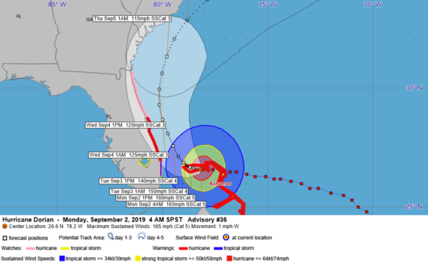
The eye of intense Hurricane Dorian is less than 115 miles east of West Palm Beach this morning. It is like staring into the eye of a monster that is playing chicken with the coast of Florida. The storm has essentially stalled, preparing for the eventual turn to the northwest and north.
It is a life or death game right now on the island of Grand Bahamas where the storm 165 mph winds are raking a hellish fury, and pushing a huge storm surge onto the island.
Even though the winds have diminished a bit, it is still a category 5 hurricane, stronger than last season’s Michael, which devastated Mexico Beach, Florida.
The cloud tops around the center seem to be cooling again on infrared satellite imagery this morning and the outflow appears to be excellent so the storm will at least maintain its intensity it appears for the short run, or even intensify again. fluctuations in intensity are common with powerful storms like Dorian. Overall, the hurricane should gradually lose intensity over the next several days, but as it starts up the coast it will still be a category 4 or 5 hurricane for much of the next two days.
The forecast track is basically unchanged.
Dorian will bring tropical-storm-force winds to much of the coasts of Florida, Georgia, South Carolina between now and Thursday, and then threatens to directly impact the North Carolina coast with possible landfall from Cape Fear to the Outer Banks.
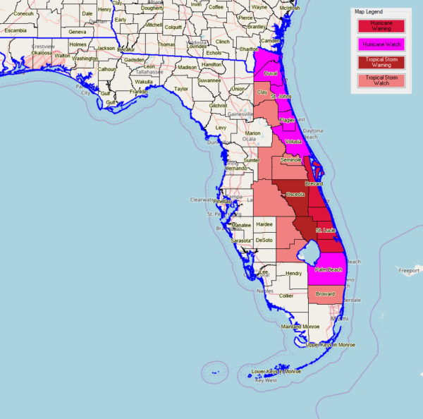
FLORIDA: Tropical-storm-force winds along its length from north of Fort Lauderdale to the Georgia border, with hurricane gusts. The NWS Melbourne warns that conditions will deteriorate rapidly early Tuesday along the East Coast of the state. 3-6 feet of surge along the coast with some concentrated areas of 6-9 feet of surge at the head of bodies of water. 4-6 inches of rain along the immediate coast.
GEORGIA: Tropical storm conditions starting Wednesday morning lasting until Thursday. Mandatory evacuations are in effect. The Georgia coast will experience a prolonged battering of onshore winds with the resulting high tides. 3-9 feet of surge across the beaches and coastal marshes well inland. 3-5 inches of rain along the coast. Mandatory evacuations are in effect.
SOUTH CAROLINA: Tropical storm conditions arrived Wednesday evening with hurricane conditions possible Thursday from Charleston to the Grand Strand around Myrtle Beach. A prolonged period of onshore flow with high tides will persist long before the center approaches. 3-6 foot surge along the beaches and tidal waterways. 3-6 inches of rain over eastern South Carolina.
NORTH CAROLINA: Tropical storm winds arrive starting Thursday, with hurricane conditions likely from a 115 mph category 3 hurricane as the hurricane scrapes the coast from Oak Island to the Outer Banks. Damage from winds and tides will be severe. 3-6 foot surge likely along the coast and at the head of inland waterways connected to the ocean in places like new Bern, which were hard hit last year. 3-8 inches of rain over eastern North Carolina.
Here are current wind warnings for the United States:
MODEL COMPS: both global models now follow the curve, but bring the hurricane over or near the North Carolina coast
UNCERTAINTY: The track could vary from this forecast by as much as 200 miles by Friday. Any deviation to the left could bring much great impacts to the coast, while a track further out to sea could lessen those impacts.
RECON REPORTS: Mission 32 has returned to base at Keesler for some reason. It will be a few hours before we have any low-level monitoring of the hurricane.
IMPACTS FOR US: No impacts for Alabama or the beaches of the Central Gulf Coast.


