A Few Showers/Storms Possible In The Southeastern Parts Of The Area; Dorian Approaches The Bahamas
CATEGORY 4 HURRICANE DORIAN NOW MOVING WEST-NORTHWESTWARD
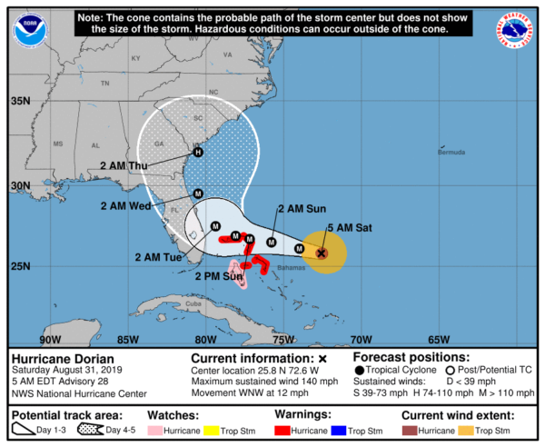
The westward turn occurred during the overnight hours and is now moving to the west-northwest at 12 MPH toward and eventually just north of the southeastern and central Bahamas today, and over the northwestern Bahamas by Sunday. As of the 4:00 am update, maximum winds are still clocking at 140 MPH. The latest track from the NHC shows the center of Dorian now curving right before making it to the east coast of Florida and moving just offshore to the north with a potential landfall around Hilton Head, South Carolina. While the forecast track doesn’t show a direct landfall on Florida, the peninsula is still located in the cone, which means that a Florida landfall is still possible. Here are the key messages for Hurricane Dorian:
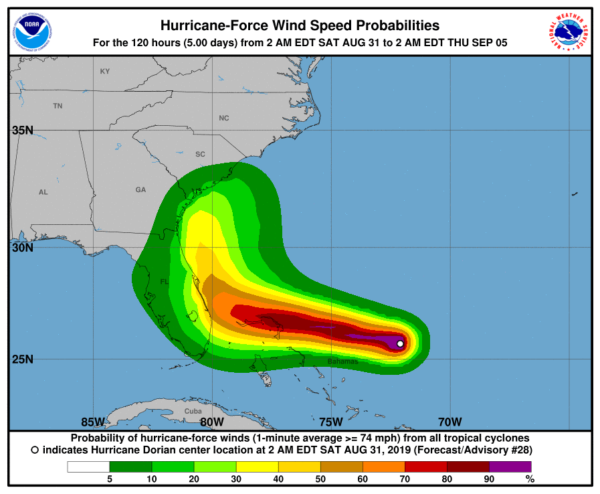
1. A prolonged period of the life-threatening storm surge and devastating hurricane-force winds are likely in portions of the northwestern Bahamas, particularly on the Abaco Islands and Grand Bahama Island. A hurricane warning is in effect for these areas, and residents should listen to the advice given by local emergency officials and have their hurricane preparations completed today.
2. Life-threatening storm surge and devastating hurricane-force winds are still possible along portions of the Florida east coast by the early to middle part of next week, but since Dorian is forecast to slow down and turn northward near the coast, it is too soon to determine when or where the highest surge and winds will occur. Residents should have their hurricane plan in place, know if they are in a hurricane evacuation zone, and listen to the advice given by local emergency officials.
3. The risk of strong winds and life-threatening storm surge is increasing along the coasts of Georgia and South Carolina during the middle of next week. Residents in those areas should continue to monitor the progress of Dorian.
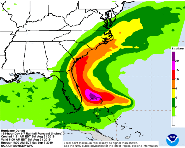
4. Heavy rains, capable of life-threatening flash floods, are expected over portions of the Bahamas and coastal sections of the southeastern United States this weekend through much of next week.
As far as Central Alabama and the Alabama Gulf Coast, none of the spaghetti plots have Dorian staying well east of the Gulf of Mexico. While we may see a few clouds from the far western periphery of Dorian, winds will be out of the northeast and north starting on Tuesday and for the remainder of the week. As you will see, that will keep rain chances out of our forecast during that time, but it will not keep our daytime highs from getting into the lower to mid-90s.
MOISTURE LEVELS INCREASE IN THE SOUTHEASTERN PARTS OF THE AREA
While much of Central Alabama will stay dry throughout this last day of August, we may see a few isolated to scattered afternoon showers and thunderstorms over the southeastern parts of the area, especially along and south of the I-85 corridor. The reason for that will be the area of high pressure that has been nearby will become distorted and more of an easterly flow will start over the southeastern parts of the area. A convergence zone will set up over those locations which will be the focal point for the development of those showers and storms during the main heating of the day. Afternoon highs will be in the upper 80s to the lower 90s. Most activity will diminish after sunset, but a few showers could linger into the late-night hours. We should be completely dry before midnight.
WEATHER FOR THE FIRST DAY OF SEPTEMBER
The convergence boundary will move northward and end up around the I-59 corridor for Sunday, which will bring an increase of moisture levels along and south of that boundary. With the heating of the day, we’ll see a chance of a few isolated to scattered afternoon showers and storms along and south of the boundary, while north of that will stay dry. Afternoon highs will be in the upper 80s to the lower 90s.
A DRY & LESS HUMID LABOR DAY
A high-pressure ridge starts to build back in from the west which will send more continental-dry air into Central Alabama on Monday. The holiday will be mainly sunny with maybe a passing cloud or two with afternoon highs hitting the lower 90s. The good news is that dewpoints will be dropping throughout the day, into the mid-60s by late afternoon.
THE REST OF THE WORK WEEK
Based on the current track of Dorian, combined with the ridge continuing to be in control of our weather, we can expect a dry week with plenty of bright sunshine and very little in the way of passing clouds. Dewpoints look to stay in the lower to mid-60s throughout the week which will make the heat feel a little more tolerable. Highs on Tuesday through Thursday will be in the lower to mid-90s, with highs dropping back into the upper 80s to the lower 90s.
BEACH FORECAST CENTER
Get the latest weather and rip current forecasts for the beaches from Fort Morgan to Panama City on our Beach Forecast Center page. There, you can select the forecast of the region that you are interested in.
 WEATHERREADY FEST: A FREE PREPAREDNESS & SAFETY FESTIVAL FOR THE ENTIRE FAMILY
The National Weather Association Foundation is bringing WeatherReady Fest to the campus of the University of Alabama in Huntsville on September 7, 2019, from 10:00 am to 4:00 pm. This one-day festival will include family-friendly games, fun learning activities, large response vehicles, and enlightening speakers. Local and national celebrities will make special appearances, along with the NWA’s very own, Owlie Skywarn. Over 6,000 attendees showed up in St. Louis for last year’s event… let’s break that record this year. Get your free timed tickets now as they are going fast. More information and a link to tickets are available on the festival website at www.weatherreadyfest.com. Hope to see you there!
ALREADY OFF TO A HOT START IN 2019! ADVERTISE WITH THE BLOG!
After a record-setting 2018 with over 19.7 million page views, AlabamaWx.com is already well on its way to setting another record as we’re just topped 12.3 million page views so far in 2019! Don’t miss out! We can customize a creative, flexible and affordable package that will suit your organization’s needs. Contact Bill Murray at (205) 687-0782.
E-FORECAST
Get the Alabama Wx Weather Blog’s Seven-Day Forecast delivered directly to your inbox by email twice daily. It is the most detailed weather forecast available in Central Alabama. Subscribe here… It’s free!
CONNECT WITH THE BLOG ON SOCIAL MEDIA
You can find the AlabamaWx Weather Blog on the major social media networks:
Facebook
Twitter
Instagram
WEATHERBRAINS
Don’t forget you can listen to our weekly 90 minute netcast anytime on the web at WeatherBrains.com or on iTunes, Stitcher, or Spotify. This is the show all about weather featuring many familiar voices, including the meteorologists at ABC 33/40.
Category: Alabama's Weather, ALL POSTS, Tropical


