Hot With Some Storms Today, Heat Levels Rise To Start Next Week
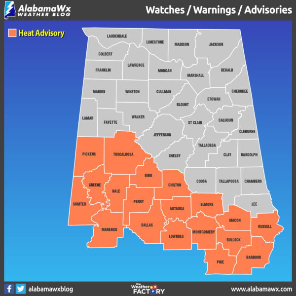
HEAT ADVISORY remains in effect through Sunday night at 9:00 pm for these counties in Central Alabama: Autauga, Barbour, Bibb, Bullock, Chilton, Dallas, Elmore, Greene, Hale, Lowndes, Macon, Marengo, Montgomery, Perry, Pickens, Pike, Russell, Sumter, and Tuscaloosa.
Moisture levels will remain rather high across Central Alabama today as precipitable water values will be near two inches. Couple that with an impulse that will be moving into the area from the northwest and some drier air in the mid-levels will work in from the north, we’ll have a zone of higher rain chances set up over the western parts of the area, mainly west of the I-22 and I-65 corridors. We’ll have scattered to numerous showers and thunderstorms across the area, most of which will occur during the afternoon and evening hours. Most of that activity will die off around 10:00 pm tonight. Highs will reach the lower to mid-90s across the area. Rain chances will be in the 40%-70% range from northeast to southwest.
Ridging moves a little closer to Central Alabama on Sunday which will bring a shift in winds to more out of the north. While the mid-levels will be drier, the lower levels of the atmosphere will stay mighty moist across the area, especially in the southern parts. Skies will be mostly sunny to partly cloudy with afternoon highs in the lower to mid-90s. Heat index values will approach and perhaps exceed 105 degrees along and south of the I-20 corridor. There will not be much help in the rainfall department to help cool us down as there is only a very small chance of an isolated afternoon shower or storm.
The ridge flattens out which will crank those afternoon temperatures up, climbing into the mid to upper 90s for Monday and Tuesday. With dewpoints expected to be in the mid-70s on both days, we could approach or exceed criteria for excessive heat warnings with heat index values near 110 degrees. Not very much help from rainfall as only a few isolated to scattered afternoon showers and storms are possible on each day. NWS Birmingham may issue an excessive heat watch as early as Sunday to go into effect for Monday and Tuesday.
Troughing will take over the eastern parts of the US for Wednesday and Thursday, and we may have the bottom end of a cold front pass through Central Alabama. We’ll see some relief from the higher heat levels but highs will remain in the lower 90s. Precipitable water values will be approaching the two-inch mark. Wednesday will feature the highest chance of scattered to numerous showers and storms (50%-60%), while those chances drop some for Thursday (20%-60% from northwest to southeast). Some gusty winds may be possible with a few of these storms, but there is no threat of organized severe weather at this point.
Friday’s weather will not be much different than Thursday as scattered showers and thunderstorms remain possible across the area mainly during the afternoon and evening hours. Rain chances will remain in the 20%-60% from northwest to southeast and afternoon highs will be in the lower 90s.
The tropics are all quiet at this point and no new tropical systems are expected to form within the next five days.
 A FREE, FUN WEATHER PREPAREDNESS & SAFETY FESTIVAL FOR THE WHOLE FAMILY
WeatherReady Fest is coming to Huntsville, Alabama on September 7, 2019, from 10:00 am to 4:00 pm. Family-friendly games, fun learning activities, large response vehicles, and enlightening speakers will highlight this big, one-day weather festival on the campus of the University of Alabama in Huntsville. Special guests include The Weather Channel’s Nick Walker, ABC 33/40’s Chief Meteorologist James Spann, and Owlie Skywarn. Each visitor will receive their very own passport booklet. Collect stamps from exhibitor for your chance to win door prizes. Tours of UAH’s SWIRLL and the NWS Huntsville office will be available as well. Get your free timed tickets quickly as they will not last long. More information and a link to the ticket site is available on the festival website at www.weatherreadyfest.com. The tickets are free and are issued for specific hours to maximize the number of people that can visit. I hope to see you there!
ON THIS DAY IN WEATHER HISTORY
1924 – Colorado’s deadliest tornado killed a woman and nine children in one house along its twenty-mile path east southeast of Thurman. Mennonite men had left the farm to provide possible aid, as the 200-yard wide storm was first seen while far away.
BEACH FORECAST CENTER
Get the latest weather and rip current forecasts for the beaches from Fort Morgan to Panama City on our Beach Forecast Center page. There, you can select the forecast of the region that you are interested in.
ALREADY OFF TO A HOT START IN 2019! ADVERTISE WITH THE BLOG!
After a record-setting 2018 with over 19.7 million page views, AlabamaWx.com is already well on its way to setting another record as we’re just topped 12 million page views so far in 2019! Don’t miss out! We can customize a creative, flexible and affordable package that will suit your organization’s needs. Contact Bill Murray at (205) 687-0782.
E-FORECAST
Get the Alabama Wx Weather Blog’s Seven-Day Forecast delivered directly to your inbox by email twice daily. It is the most detailed weather forecast available in Central Alabama. Subscribe here… It’s free!
CONNECT WITH THE BLOG ON SOCIAL MEDIA
You can find the AlabamaWx Weather Blog on the major social media networks:
Facebook
Twitter
Instagram
WEATHERBRAINS
Don’t forget you can listen to our weekly 90 minute netcast anytime on the web at WeatherBrains.com or on iTunes, Stitcher, or Spotify. This is the show all about weather featuring many familiar voices, including the meteorologists at ABC 33/40.
Category: Alabama's Weather, ALL POSTS, Weather Xtreme Videos


