Scattered Storms Out There At Midday
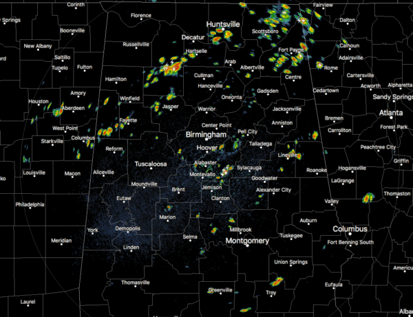
At 12:10 pm, we have a good bit of scattered shower and thunderstorm activity over the northern half of the area while a few isolated showers and storms have popped up over the southern half of Central Alabama. None of these showers or storms are particularly strong at the moment, but some of these do include dangerous cloud-to-ground lightning. All of the activity is pushing off slowly to the east-southeast. Temperatures were in the lower 80s to the lower 90s across the area. Birmingham was at 90 degrees. The cool spot was Alabaster at 81 degrees with rain-cooled air. The hot spot was Uniontown at 93 degrees.
For today, we’ll continue to have a chance of isolated to scattered showers and thunderstorms across Central Alabama for the remainder of the afternoon and into the early evening hours. Highs will top out in the upper 80s to the mid-90s. Rain chances will range from 20%-50%, but the highest chances will be north of the I-85 corridor. For tonight, much of the activity will diminish after the sun goes down, but a few showers and storms could linger around for several more hours. Lows will be in the upper 60s to the lower 70s.
Much of the same story for Thursday as we’ll continue to have a chance of isolated to scattered showers and thunderstorms mainly during the late morning through the early evening hours. Afternoon highs will be in the lower to mid-90s. Rain chances will be in the 20%-50% range once again, with the highest chances coming along and south of the I-59 corridor down to the I-85 corridor.
INVEST 95L OVER THE CARIBBEAN
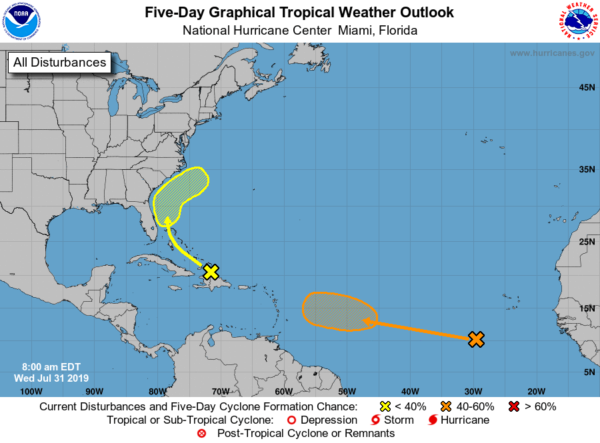
A disorganized tropical wave continues to bring showers and thunderstorms to the Virgin Islands, Puerto Rico, and Hispanola. It will begin to curve to the northwest at 10 MPH and head toward the eastern coast of Florida and the Bahamas over the next few days. Some development could occur once it reaches there, but the NHC is only going with a 10% chance of it developing into a depression within the next five days.
EYES ON THE TROPICAL WAVE OVER THE EASTERN ATLANTIC AS WELL
A little higher risk of development for the wave that is currently moving westward around 15 MPH across the eastern Atlantic Ocean. Conditions are not favorable at this point, but it will move into better conditions by the end of the week and weekend where we could see a depression form well east of the Lesser Antilles. At this point, NHC is giving it a 50% chance of developing into a depression within the next 5 days.
ON THIS DAY IN WEATHER HISTORY
1976 – A stationary thunderstorm produced more than ten inches of rain which funneled into the narrow Thompson River Canyon of northeastern Colorado. A wall of water six to eight feet high wreaked a twenty-five-mile path of destruction from Estes Park to Loveland killing 156 persons. The flash flood caught campers and caused extensive structural and highway damage. Ten miles of U.S. Highway 34 were destroyed as the river was twenty feet higher than normal at times.
1987 – The deadliest tornado in 75 years struck Edmonton, Alberta, killing 26 persons and injuring 200 others. The twister caused more than 75 million dollars damage along its nineteen-mile path, leaving 400 families homeless. At the Evergreen Mobile Home Park, up to 200 of the 720 homes were flattened by the tornado.
BEACH FORECAST CENTER
Get the latest weather and rip current forecasts for the beaches from Fort Morgan to Panama City on our Beach Forecast Center page. There, you can select the forecast of the region that you are interested in.
ALREADY OFF TO A HOT START IN 2019! ADVERTISE WITH THE BLOG!
After a record-setting 2018 with over 19.7 million page views, AlabamaWx.com is already well on its way to setting another record as we’re nearing 12 million page views so far in 2019! Don’t miss out! We can customize a creative, flexible and affordable package that will suit your organization’s needs. Contact Bill Murray at (205) 687-0782.
E-FORECAST
Get the Alabama Wx Weather Blog’s Seven-Day Forecast delivered directly to your inbox by email twice daily. It is the most detailed weather forecast available in Central Alabama. Subscribe here… It’s free!
CONNECT WITH THE BLOG ON SOCIAL MEDIA
You can find the AlabamaWx Weather Blog on the major social media networks:
Facebook
Twitter
Instagram
WEATHERBRAINS
Don’t forget you can listen to our weekly 90 minute netcast anytime on the web at WeatherBrains.com or on iTunes, Stitcher, or Spotify. This is the show all about weather featuring many familiar voices, including the meteorologists at ABC 33/40.
Category: Alabama's Weather, ALL POSTS


