Occasional Tropical Showers Over The Weekend
RADAR CHECK: Tropical showers continue to increase across all of Alabama this afternoon as deep moisture is pulled northward on the east side of the circulation of Tropical Storm Barry in the northern Gulf of Mexico. The showers are moving slowly northward, and if you are under one you get heavy rain along with some lightning. We will maintain the chance of showers and thunderstorms across Alabama tonight.
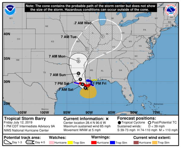
UPDATE ON BARRY: Tropical Storm Barry is now packing sustained winds of 65 mph in the northern Gulf of Mexico, and is drifting very slowly to the west/northwest (5 mph). It now expected to reach category one hurricane strength by the time of landfall early tomorrow morning. A Hurricane Warning is in effect from Intracoastal City to Grand Isle, Louisiana, and a storm surge waring is in effect from Intracoastal City to Biloxi and for Lake Pontchartrain.
Tropical-storm-force winds extend outward up to 175 miles from the center. The NOAA automated station at the Southwest Pass of the Mississippi River recently reported sustained winds of 55 mph and a wind gust of 66 mph at an elevation of 125 ft. An oil rig located southwest of the Mouth of the Mississippi River recently reported sustained winds of 76 mph and a wind gust of 87 mph at an elevation of 295 ft.
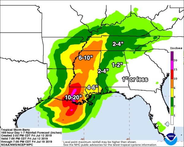
Barry will slowly move through Louisiana and Arkansas over the weekend. The axis of heaviest rain has been shifted a tad to the west on the latest forecast update from NOAA’s WPC (Weather Prediction Center). Amounts of 10-20 inches are possible in a narrow zone over Southeast Louisiana; for now that appears most likely a little west of New Orleans and Baton Rouge. Those two cities, however, can easily see 6-10 inches of rain over the next 48 hours. Amounts in that same range (6-10 inches) are likely over a decent part of Mississippi.
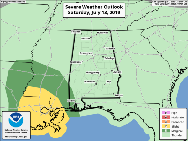
IN ALABAMA: We will deal with occasional tropical showers and a few thunderstorms over the weekend. The showers are most likely from 12:00 noon until 12:00 midnight, but a few late night and morning showers can’t be ruled out in this pattern. The heaviest rain is likely over the southwest counties of the state, and a flash flood watch is in effect for Choctaw, Washington, Mobile, Baldwin, and Escambia counties.
Average rain amounts for West Alabama will be in the 2-4 inch range, with 1-2 inches to the east. But remember, rain distribution will not be very even with a tropical system like this.
There is potential for a few isolated, brief tornadoes in the rain bands on the east side of Barry tomorrow and Sunday over Mississippi, and we will need to watch cell in far West Alabama for signs of rotation. But, for now, it looks like the main threat of a tornado or two will be west of our state.
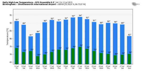
The sun will be out at times tomorrow and Sunday, but with an increase in clouds and showers temperatures should hold in the 80s both days.
TRAVEL: I am getting so many questions about driving conditions tomorrow and over the weekend across the Southeast U.S. I possess no special knowledge or skill about future road conditions. All depends on risk tolerance… and that is different for different people. Just pay attention to NWS watches and warnings and keep up with the latest weather information to help you make a good decision.
NEXT WEEK: Scattered to numerous showers and storms remain likely Monday, but the pattern trends back to the routine summer setup by mid-week as the remnant circulation of Barry moves away from the region. See the Weather Xtreme video for maps, graphics, and more details.
ON THIS DATE IN 1996: Hurricane Bertha makes landfall near Wrightsville Beach, NC with maximum winds of 105 mph, but the storm surge dealt the most devastation. The U.S. Virgin Islands, along with North Carolina, were declared federal disaster areas. Surveys indicate that Bertha damaged almost 2,500 homes on St. Thomas and St. John. For many, it was the second hit in the ten months since Hurricane Marilyn devastated the same area. The primary effects in North Carolina were to the coastal counties and included storm surge flooding and beach erosion, roof damage, piers washed away, fallen trees and damage to crops. Over 5,000 homes were damaged, mostly from storm surge. Storm total rainfall amounts ranged from 5 to 8 inches along a coastal strip from South Carolina to Maine. Overall, as many as 12 deaths resulted with 8 in the U.S. and territories.
BEACH FORECAST: Click here to see the AlabamaWx Beach Forecast Center page.
WEATHER BRAINS: Don’t forget you can listen to our weekly 90 minute show anytime on your favorite podcast app. This is the show all about weather featuring many familiar voices, including our meteorologists here at ABC 33/40.
CONNECT: You can find me on all of the major social networks…
Facebook
Twitter
Instagram
Pinterest
Snapchat: spannwx
Look for my next Weather Xtreme video here by 7:00 a.m. Monday, and we will have frequent update on Tropical Storm Barry here on the blog tonight, tomorrow, and Sunday. Enjoy the weekend!
Category: Alabama's Weather, ALL POSTS, Weather Xtreme Videos


