Sun, Heat, Afternoon Storms
**No afternoon Weather Xtreme video today; we are on a holiday schedule. Back to the two a day routine Monday**
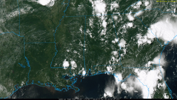
RADAR CHECK: Another classic summer afternoon across Alabama. The day is hot and humid, and we have the usual random array of scattered showers and thunderstorms on radar. Stronger storms are producing frequent lighting and heavy rain, and are moving slowly eastward. They will fade away once the sun goes down later this evening. Away from the storms, the sky is partly sunny with temperatures between 90 and 95 degrees.
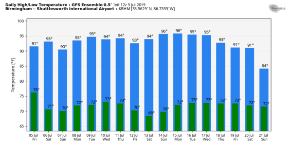
THE ALABAMA WEEKEND: Not much change. Mixed sun and clouds tomorrow and Sunday with “scattered, mostly afternoon and evening showers and thunderstorms”. The chance of any one spot getting wet tomorrow is about one in three, and in the 40/50 percent range Sunday. Most of the storms will come from 1:00 until 9:00 p.m. Afternoon highs will be the 90-95 degree range tomorrow, and between 88 and 92 Sunday.
NEXT WEEK: No change Monday, but showers and storms should be fewer in number on Tuesday and Wednesday due to drier air in the mid levels. Global models (both the GFS and the ECMWF) continue to give a signal of a potential tropical low around the Gulf Coast toward the end of next week. It remains to be seen if this will actually happen, or if it will impact Alabama. We will trend toward higher POPs (probability of precipitation) by Friday July 12, but there is great uncertainty for now. We will watch model trends closely in coming days.
TROPICS: The Atlantic basin will remain quiet this weekend…. over in the eastern Pacific Barbara has weakened to a tropical storm, and should dissipate before reaching Hawaii early next week.
ON THIS DATE IN 1980: The “More Trees Down” Derecho… A bowing line of thunderstorms producing a derecho formed just east of Omaha, Nebraska around 10 p.m. CDT on Friday evening, July 4th, 1980. The system rushed east at a speed of 55 to 60 mph, reaching eastern Indiana and northwest Ohio by 8 a.m. EDT on Saturday, July 5th, and the mid Atlantic coast by early evening on the 5th. Measured wind gusts exceeded 80 mph at several points along the storm’s track. Six people were killed, and 67 were injured by the derecho’s winds.
BEACH FORECAST: Click here to see the AlabamaWx Beach Forecast Center page.
WEATHER BRAINS: Don’t forget you can listen to our weekly 90 minute show anytime on your favorite podcast app. This is the show all about weather featuring many familiar voices, including our meteorologists here at ABC 33/40.
CONNECT: You can find me on all of the major social networks…
Facebook
Twitter
Instagram
Pinterest
Snapchat: spannwx
Look for the next Weather Xtreme video by 7:00 a.m. Monday… enjoy the weekend!
Category: Alabama's Weather, ALL POSTS, Weather Xtreme Videos


