At Midday: Parts Of Central Alabama Upgraded To A Slight Risk
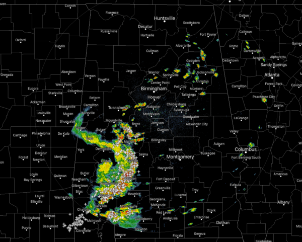
CONDITIONS AT 11:40 AM
We continue to see a cluster of strong thunderstorms move across the southwestern parts of Central Alabama and down into South Alabama that is putting down copious amounts of rainfall, dangerous cloud-to-ground lightning, and gusty winds with gusts up to 40 MPH possible. Marengo County was previously under a Severe Thunderstorm Warning, but the cell that caused that weakened enough for the warning to be allowed to expire.
For the rest of Central Alabama, we have a few small scattered showers now starting to fire up in the east-central and northeastern parts of the area. None of these are producing lightning at this point.
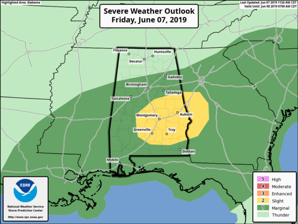
SPC continues a Marginal Risk for much of Central Alabama, while they have upgraded the south and southeastern parts to a Slight Risk for severe storms through the rest of the day. Damaging winds up to 60 MPH will be the main threat, but we can’t rule out a brief isolated tornado or two.
MORE RAIN & STORMS LIKELY THROUGH TONIGHT
We’ll continue to have showers and a few thunderstorms develop and move across the area throughout the remainder of the afternoon and evening hours. Some of these storms could pack a punch with strong gusty winds possible. Highs will top out in the lower 80s to the lower 90s across the area from northwest to southeast. Rain will continue to be likely throughout the late night and overnight hours. A few thunderstorms may be possible with a very small possibility of one or two becoming strong. Lows will be in the upper 60s to the lower 70s.
WET WEATHER CONTINUES THROUGH THE WEEKEND
We’ll continue to have periods of rain and some thunderstorms mixed in on both Saturday and Sunday as tropical moisture continues to be socked in over Central Alabama. We’ll have some breaks in the rain and the sun may even peek out at times. The good news is that there is no threat of organized severe storms, but as with today, one or two storms may become strong. Highs will be in the lower to mid-80s on both days.
A QUICK LOOK AT THE TROPICS
The Atlantic Basin remains quiet today and no new tropical cyclones are expected to develop during the next five days.
ON THIS DAY IN WEATHER HISTORY
1989 – Thunderstorms produced severe weather from southern Oklahoma and eastern Texas to northwestern Florida through the day and night. Thunderstorms spawned 22 tornadoes, including a dozen in Louisiana, and there were 119 reports of large hail and damaging winds. A strong (F-2) tornado at Gross Tete LA killed two persons, injured thirty others, and another strong (F-2) tornado injured 60 persons at Lobdell LA. Softball size hail was reported at Hillsboro TX.
BEACH FORECAST CENTER
Get the latest weather and rip current forecasts for the beaches from Fort Morgan to Panama City on our Beach Forecast Center page. There, you can select the forecast of the region that you are interested in.
ALREADY OFF TO A HOT START IN 2019! ADVERTISE WITH THE BLOG!
We have enjoyed over 10 MILLION page views on AlabamaWx.com so far in 2019! Don’t miss out! We can customize a creative, flexible and affordable package that will suit your organization’s needs. Contact Bill Murray at (205) 687-0782.
E-FORECAST
Get the Alabama Wx Weather Blog’s Seven-Day Forecast delivered directly to your inbox by email twice daily. It is the most detailed weather forecast available in Central Alabama. Subscribe here… It’s free!
CONNECT WITH THE BLOG ON SOCIAL MEDIA
You can find the AlabamaWx Weather Blog on the major social media networks:
Facebook
Twitter
Instagram
WEATHERBRAINS
Don’t forget you can listen to our weekly 90 minute netcast anytime on the web at WeatherBrains.com or on iTunes, Stitcher, or Spotify. This is the show all about weather featuring many familiar voices, including the meteorologists at ABC 33/40.
Category: Alabama's Weather, ALL POSTS, Severe Weather


