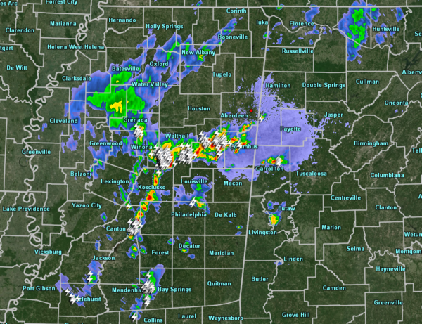
Most Of The Action In Mississippi At 7:00 PM… Still Waiting In North/Central Alabama
At 7:00 pm, there are only a couple of isolated thunderstorms over the northern part of Pickens County and over the southwestern part of Greene County. The main action is to the west over the east-central parts of Mississippi as storms continue to strengthen. These are moving to the north-northeast at around 25 MPH. If these storms can hang together, they may move into the northwestern parts of the area by 9:00 pm.
Other than those, the rest of North/Central Alabama continues to stay rather quiet. As we are now losing the sunlight and the temperatures are starting to drop, we’ll have to see if the atmosphere can hang on to some of the instability to continue to threat of severe weather throughout the rest of the night and through the early morning hours on Tuesday.
SPC continues a Slight Risk for locations west of a line from Cuba to Heiberger to Chelsea to Baileyton to Madison. A Marginal Risk continues for the rest of the state. Main threats are damaging winds up to 60 MPH and quarter-size hail, but an isolated tornado or two cannot be ruled out for the rest of today and into tonight.
Timing is for the potential for severe storms across the area is from now until 10:00 am Tuesday morning. The window for the potential of severe storms in the northwestern-third is from now until 2:00 am Tuesday, in the central-third from now until 6:00 am, and for the southeastern-third until 10:00 am.
If anything else forms and becomes strong, we’ll have an update ready for you. Stay tuned.
Category: Alabama's Weather, ALL POSTS, Severe Weather


