Some Showers Out There At Midday, Main Event Still To Come Later Today
At 12:10 pm, we still have some shower activity over the extreme parts of North Alabama at this point, but nearly the rest of the area is dry. It looks like we have some light activity moving in over the southwestern parts of the area, but more than likely, that activity is not reaching the ground at this point.
Instability continues to build over the western half of the state with much of the area already over 500 J/kg, with some locations in the southwestern parts already over 1000 J/kg.
Helicity values in the lower levels (0-1 km) continue to rise as well with values now approaching 300 m2s2 in the northwestern parts of the state. We see much higher values already over northern Mississippi topping out at 450 m2s2, more than enough for supercell development with rotating updrafts.
Unfortunately, STP values have climbed drastically since I did the Weather Xtreme video this morning, as the latest HRRR shows values around 5.0 over the northwestern parts of the state at 5:00 pm this evening. Any values over 1.0 mean a significant tornado is possible.
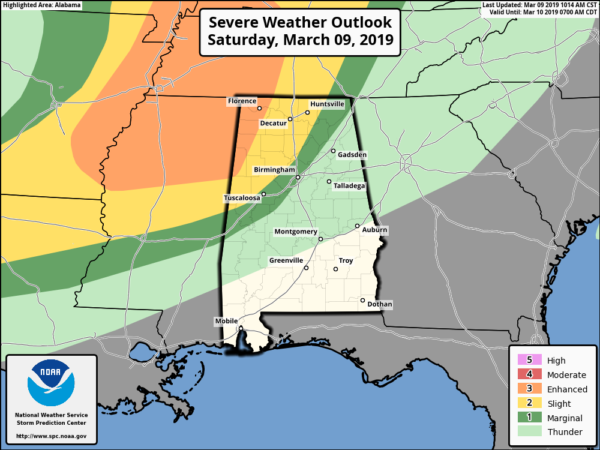
SPC continues the Enhanced Risk for severe storms over the northwestern corner of the area west of a line from roughly Millport to Phil Campbell to Lexington, a Slight Risk for locations east of that to a line stretching from Geiger to Warrior to Hytop, and a Marginal Risk for locations east of that to a line stretching from Cuba to Brent to Ider.
Timing of the stronger to severe storms continue to be from 3:00 pm CST this afternoon to 3:00 am CDT Sunday morning. All modes of severe weather continue to be possible: tornadoes, damaging winds up to 70 MPH, and large hail. A strong tornado or two are possible in the Enhanced Risk locations.
Once again… Now is the time to have your plan of safety, safety kit, and safe place ready to go in case your location goes under a warning. If you live in a mobile/manufactured home and you are in a tornado warning polygon, you MUST leave and take shelter in a more sturdy structure or a storm shelter. Have your cellphones fully charged and fresh batteries in your portable radios and your NOAA WeatherRadio. We’ll keep you updated throughout the event.
Category: Alabama's Weather, ALL POSTS, Severe Weather


