Severe Storms Possible Sunday
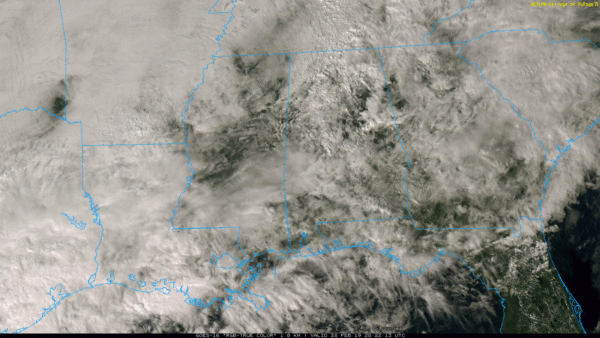
RADAR CHECK: A few lingering showers are over Alabama in scattered spots this afternoon… these showers will diminish during the evening hours. We can’t rule out a few showers overnight, but they should be widely spaced.
TOMORROW/SATURDAY: The weather will be fairly quiet on these two days; a few showers are possible, but the rain won’t be too widespread, and the sun should peek out at times. Afternoon highs will be in the low to mid 60s.
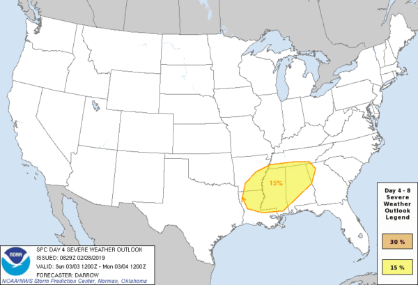
SEVERE STORMS POSSIBLE SUNDAY: A cold front will slice into an increasingly unstable airmass over Alabama Sunday, setting the stage for strong to severe storms and significant rain amounts. SPC has defined a severe weather threat for much oF Alabama, Mississippi, and parts of the adjacent states.
A surface low is expected to pass just north of Alabama, and based on the projected wind fields it looks like thunderstorms on Sunday will be capable of producing hail, strong straight line winds, and a few tornadoes. For now it looks like the main window for severe storms will come from 10:00 a.m. until 6:00 p.m. We will be able to be much more specific tomorrow, as we get within the 60 hour window of the convection allowing models (CAMs). These offer much higher grid resolution and handle severe weather events much better.
Rain amounts of 1-2 inches are expected Sunday. The high Sunday afternoon will be in the 60s, but in the wake of a cold front much colder air will roll into the state Sunday night. As the rain moves out, a few snow flurries are possible over the northern quarter of Alabama Sunday night and early Monday, but no impact is expected.
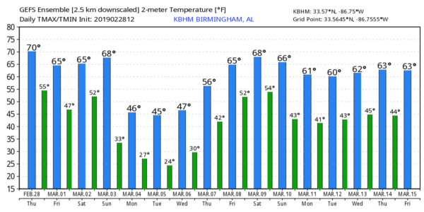
COLD AIR RETURNS: The first half of next week will feature temperatures well below average for early March. Highs will be only in the 40s Monday through Wednesday, and early morning low will be well below freezing Tuesday, Wednesday, and Thursday morning. The coldest mornings will come early Tuesday and Wednesday when temperatures drop into the 20-25 degree range… colder spots will see upper teens. Look for a warming trend Thursday and Friday… and the week looks mostly rain-free. See the Weather Xtreme video for maps, graphics, and more details.
ON THIS DATE IN 1987: Glade, Mississippi (near Laurel) was struck by a 2 mile wide EF-4 tornado. The tornado began near Moselle, MS and rapidly developed. The tornado swept homes off of their foundations, flattened trees in the path and completely destroyed Glade Elementary School ($5 million in damage to the school alone). Six fatalities occurred in the Glade Community and 350 injuries occurred.
ON THIS DATE IN 2011: Four tornadoes touched down in Alabama… all EF-0 or EF-1. The damage was in Talladega, Autauga, Elmore, Chambers, and Lowndes counties. It served as the beginning of the most active tornado season on record for the state.
BEACH FORECAST: Click here to see the AlabamaWx Beach Forecast Center page.
WEATHER BRAINS: Don’t forget you can listen to our weekly 90 minute show anytime on your favorite podcast app. This is the show all about weather featuring many familiar voices, including our meteorologists here at ABC 33/40.
CONNECT: You can find me on all of the major social networks…
Facebook
Twitter
Instagram
Pinterest
Snapchat: spannwx
I had a great time today visiting with the third graders at Vincent Elementary… be looking for them on the Pepsi KIDCAM today at 5:00 on ABC 33/40 News! The next Weather Xtreme video will be posted here by 7:00 a.m. tomorrow…
Category: Alabama's Weather, ALL POSTS, Weather Xtreme Videos


