Scattered Showers Tomorrow; Flooding Possible Next Week
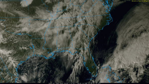
HIGH CLOUDS BUT DRY: A canopy of high cirrus clouds is over Alabama this afternoon; we still have some filtered sunshine with temperatures mostly in the low 60s. Nothing on radar, and we will stay dry tonight.
TOMORROW AND THE WEEKEND: Tomorrow will be mostly cloudy, with scattered showers possible as a cold front drifts down toward the Alabama/Tennessee border. Nothing too heavy or widespread, and the high will be in the 60-65 degree range. Showers will be a bit more widespread tomorrow night as the front continues to move slowly southward through the northern part of the state.
The front is expected run out of gas somewhere around U.S. 80 Saturday morning. This means the northern half of the state will be mostly dry Saturday with only an outside risk of a shower, and the sun might even pop out at times. The high Saturday will be around 60 for places like Birmingham, Anniston, and Tuscaloosa, with 50s to the north. Scattered showers will remain possible over South Alabama Saturday with high in the 60s.
Then, on Sunday, the boundary will drift northward as a warm front, and showers are possible statewide. Otherwise, Sunday will be mostly cloudy with a high between 66 and 70 degrees. It won’t rain all day Sunday, and amounts should be under 1/2 inch for most places.
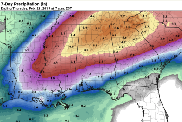
NEXT WEEK: We will maintain the chance of scattered showers Monday, then we are looking at a potential multiple day excessive rain event Tuesday through at least Thursday. A persistent upper trough west of the state, combined with a stalled surface boundary and very high precipitable water values suggest rain potential of at least 4-7 inches over North Alabama during this time; flooding is a very real concern. Of course, we are still several days away from this, and the forecast could change. But, if you are in a flood prone area, be aware of the potential.
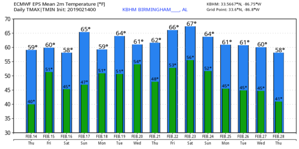
Temperatures next week will be fairly mild with highs in the 60s; we see no sign of any excessively cold air for Alabama and the Deep South for at least the next 7 to 10 days. See the Weather Xtreme video for maps, graphics, and more details.
EL NINO IS HERE: NOAA has officially declared an El Nino ENSO (El Nino Southern Oscillation) phase has started. This year’s El Niño appears to be weaker than normal and isn’t expected to last as long — just through the spring. Correlating weather to an ENSO phase is not always easy, but often in Alabama spring months during an El Nino phase can be very wet. Severe storms are always possible around here in March, April, and May… our spring severe weather season, but often during an El Nino phase we tend to see a below average number of tornadoes. And, if by chance the El Nino lasts into summer, it can serve to reduce the number of hurricanes we see in the Atlantic basin.
BEACH FORECAST: Click here to see the AlabamaWx Beach Forecast Center page.
WEATHER BRAINS: Don’t forget you can listen to our weekly 90 minute show anytime on your favorite podcast app. This is the show all about weather featuring many familiar voices, including our meteorologists here at ABC 33/40.
CONNECT: You can find me on all of the major social networks…
Facebook
Twitter
Instagram
Pinterest
Snapchat: spannwx
I enjoyed seeing the third graders today at Oak Grove Elementary… be looking for them on the Pepsi KIDCAM today at 5:00 on ABC 33/40 News! The next Weather Xtreme video will be posted here by 7:00 a.m. tomorrow…
Category: Alabama's Weather, ALL POSTS, Weather Xtreme Videos


