The Rest Of Valentine’s Day Will Stay Dry, Rain Chances Return Very Early On Friday
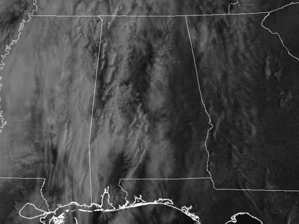
CONDITIONS ACROSS CENTRAL ALABAMA AT 11:15 AM
Skies over the eastern half of the area are mostly clear as we are making the run-up to the midday hour, while skies are becoming mostly cloudy in the west. Unfortunately, our chances of seeing any rays from the sun will continue to drop throughout the rest of the day. The good news is that we are all dry and we should stay that way for the rest of the day and for tonight. That may change once we pass the midnight hour. Temperatures across Central Alabama are in the lower 50s to the lower 60s from north to south. Cullman was the cold spot at 51 degrees while the warm spot was Eufaula at 61 degrees. Birmingham was at 55 degrees at the time.
WEATHER FOR THE REST OF YOUR THURSDAY
Clouds will continue to be on the increase throughout the rest of the afternoon and into the early evening hours, so I believe we can leave those umbrellas at home for tonight for our dates with our Valentine’s. Afternoon highs will reach the 60s across the area. We do have a small chance of a few scattered showers during the overnight hours, especially after midnight, but we’ll stay dry for tonight prior to midnight. Lows will be down in the upper 40s to the lower 50s.
MUCH OF CENTRAL ALABAMA COULD SEE SHOWERS ON FRIDAY
We’ll have a cold front start to make its way through Central Alabama from the north and that will bring a chance of showers for much of the area, especially north of a line from Demopolis to Montgomery to Phenix City. Rain will be likely in the northern parts of the area with decreasing chances as you move south. Overall rain chances will range from 20% to 70%. Highs will be in the lower 60s to the lower 70s. Rain chances will continue to increase for Friday night as the cold front continues to head toward the Gulf Coast. Rain will be likely along and north of the I-20 corridor, while a good chance of showers exists south of that. Lows will be in the mid-40s to the lower 60s across the area from north to south.
NEXT WEEK IS SEVERE WEATHER AWARENESS WEEK
The week of February 17th-22nd has been declared Severe Weather Awareness Week by Governor Kay Ivey. NWS Birmingham, Alabama EMA, and other supporting organizations are asking for help to provide the public with severe weather safety information, and the AlabamaWx Weather Blog team will be glad to help. We’ll have special infographics to go along with each severe weather safety post that is made throughout the week. Governor Ivey has also declared the weekend of February 22nd-24th as an Alabama sales tax holiday for severe weather preparedness items.
ON THIS DAY IN WEATHER HISTORY
2004 – Dallas receives 3 inches of snow, wreaking havoc with Valentine’s Day flower deliveries. The greatest snowfall since 1978 caused numerous traffic accidents, power outages and flight cancellations at Dallas-Fort Worth International Airport.
BEACH FORECAST CENTER
Get the latest weather and rip current forecasts for the beaches from Fort Morgan to Panama City on our Beach Forecast Center page. There, you can select the forecast of the region that you are interested in.
CONNECT WITH THE BLOG ON SOCIAL MEDIA
You can find the AlabamaWx Weather Blog on the major social media networks:
Facebook
Twitter
Category: Alabama's Weather, ALL POSTS


