Active Weather Pattern Continues: Cold, Wind, Eclipse, Mid-Week Warmup, Rain, Flurries, Snow Next Weekend?
WINTER SEVERE WEATHER OUTBREAK: A significant tornado struck downtown Wetumpka on Saturday afternoon, capping a severe weather event that pretty much turned out like we expected. The event was limited in scale, but still produced a significant tornado. Fairly typical for a low instability, high shear winter severe weather event in Alabama.
ANOTHER TYPICAL FEATURE: Severe weather events are often followed by significant cold snaps, and that is the case this weekend. Temperatures fell into the 30s quickly last evening behind the strong cold front. A few snow flurries showed up overnight in the colder air. But no accumulations were reported.
HIGHS TODAY: Full on cold air advection will continue all day today with strong northwesterly winds transporting in frigid air. High temperatures today will not get out of the 30s and wind chills will be in the 10-20 degrees range all day. Wind advisories are in effect. Skies will gradually clear, setting the stage for a big event tonight.
BLOOD MOON TONIGHT: A full lunar eclipse will occur tonight. It will be visible in Alabama, starting around 10:41 p.m. CST The moon will gradually take on a reddish hue as the Earth casts its shadow across the face of the moon. The entire event will take about three and one half hours. It will be quite cold however, with temperatures falling quickly into the 20s as the event unfolds. By morning, low temperatures will range from 22F across the US-278 corridor to around 22-26F in the I-20 Corridor to middle and upper 20s across southern parts of Central Alabama.
HOLIDAY FORECAST: Monday will be a clear and cool day with highs in the 40s.
NEXT WEATHERMAKER: Tuesday will feature increasing cloudiness, windy conditions, and moderating temperatures. Highs will be in the middle 50s. As low pressure moves across Missouri, showers will break out by late afternoon across western Alabama. Rain will increase during the evening hours, and a line of strong storms will push across the state during the overnight hours. Rain will end Thursday morning, although it may mix with a little light snow before it is finished. It will turn colder again behind another cold front, with highs on Thursday remaining in the 40s. Lows by Friday morning will be near or below freezing.
INTO THE WEEKEND: Friday looks dry and so does Saturday. Just cold with highs in the 40s and lows in the upper 20s. Friday could see highs below freezing all day if the GFS is right.
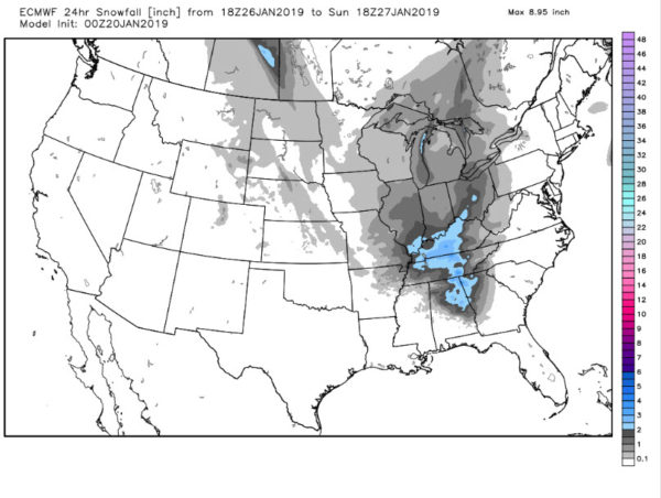
BUT NOT SO FAST MY FRIEND: The European develops a decent snow over the weekend for parts of North Central Alabama, spotting out 2-3 inches for parts of Northeast Alabama from Birmingham northeast. Both models hint at the disturbances in a northwest flow pattern. The Euro is just more bullish on the snow possibilities than the GFS, which doesn’t see them at all for us right now.
VOODOO TERRITORY: End of the month looks wet but liquid wet, not snowy wet.
GULF COAST WEATHER: Generally cool conditions will prevail through the week ahead. Lows will generally be in the 30s and highs in the 50s, except for Wednesday, when temps may reach 70F. Click here to see the Beach Forecast Center page.
WEATHERBRAINS: This week, the panel will be talking about using ensembles to portray uncertainty to audiences. Greg Fishel, a famous North Carolina meteorologist will join us. Check out the show at www.WeatherBrains.com. You can also subscribe on iTunes. You can watch the show live at live.bigbrainsmedia.com You will be able to see the show on the James Spann 24×7 weather channel on cable or directly over the air on the dot 2 feed.
ON THIS DATE IN 1985: Birmingham residents woke up on Sunday morning with an inch of snow on the ground and temperatures in the deep freeze. Readings remained in the single digits all day. The high temperature at Muscle Shoals never got above zero that day.
Follow my weather history tweets on Twitter. I am @wxhistorian at Twitter.com.
Category: ALL POSTS


