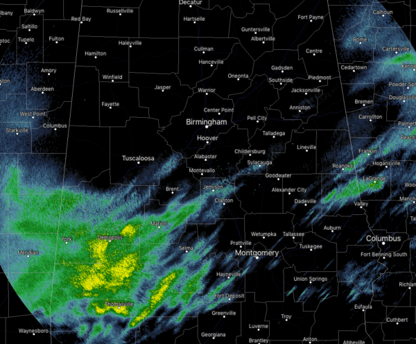
More Showers Already Starting To Move Back In At Midday
CONDITIONS ACROSS CENTRAL ALABAMA AT 12:00 PM
While most of us are seeing a decent break in the rain activity across Central Alabama, the unfortunate news is that more showers are starting to move into the southwestern sections of the area. Rain is falling over parts of the counties already under a Flash Flood Watch until 6:00 am Friday, which includes Greene, Hale, Marengo, Pickens, and Sumter counties. This activity is moving to the east-northeast and will soon be affecting such cities as Marion, Selma, Brent, Maplesville, and Fort Deposit. There is another small batch of light showers and drizzle moving over parts of Tallapoosa, Elmore, and Chambers counties. These will be out of the state shortly.
The rest of Central Alabama is dry at this point with cloudy skies. Temperatures are currently in the upper 40s to the mid-60s across the area from northwest to the southeast, with the warm spot being Troy at 64 degrees. The cool spot is in Haleyville at 48 degrees. Birmingham was at 54 degrees.
WEATHER FOR THE REST OF YOUR THURSDAY
More showers will continue to move in from the southwest during the afternoon hours for a while before more organized rain moves in later this evening and through the late night and overnight hours. Skies will remain cloudy when there is not any rain falling with afternoon highs topping out in the lower 50s to the upper 60s across the area from northwest to southeast. For tonight, those heavier showers and maybe a couple of rumbles of thunder will move in starting around the 10:00 pm time frame in the western parts of the area, to the I-65 corridor by midnight, and in the eastern parts by 2:00 am. Overnight lows will be in the upper 40s to the lower 60s.
WET AT TIMES ON FRIDAY
Much of the heavier rain activity will persist through the morning hours but should move out of the state by late morning just before midday. After that, a few scattered light showers and drizzle may linger around through the rest of the daylight and into the evening hours. We should finally be all dry before midnight and we’ll begin a good stretch of drier weather for several days. Afternoon highs will be in the lower 50s to the mid-60s with overnight lows in the mid-30s to the lower 40s. While there is a very small chance of showers late Monday and into early Tuesday, the latest model run is trending much drier than previous runs.
BEACH FORECAST CENTER
Get the latest weather and rip current forecasts for the beaches from Fort Morgan to Panama City on our Beach Forecast Center page. There, you can select the forecast of the region that you are interested in.
WE HAD A RECORD-BREAKING YEAR IN 2018! ADVERTISE WITH US TODAY ON THE ALABAMAWX WEATHER BLOG!
We have enjoyed over 19.9 MILLION page views on AlabamaWx.com for 2018… breaking our previous record by over 3 million page views. Don’t miss out! We can customize a creative, flexible and affordable package that will suit your organization’s needs. Contact Bill Murray at (205) 687-0782.
E-FORECAST
Get the Alabama Wx Weather Blog’s Seven-Day Forecast delivered directly to your inbox by email twice daily. It is the most detailed weather forecast available in Central Alabama. Subscribe here… It’s free!
CONNECT WITH THE ALABAMAWX WEATHER BLOG ON SOCIAL MEDIA
You can find the AlabamaWx Weather Blog on the major social media networks:
Facebook
Twitter
WEATHERBRAINS
Don’t forget you can listen to our weekly 90 minute netcast anytime on the web at WeatherBrains.com or on iTunes, Stitcher, or Spotify. This is the show all about weather featuring many familiar voices, including the meteorologists at ABC 33/40.
ON THIS DAY IN WEATHER HISTORY
1777 – An overnight freeze enabled George Washington and his troops to flank the British at Trenton, cross their lines at Princeton, and seek security in the hills of northern New Jersey.
Category: Alabama's Weather, ALL POSTS


