First Look at Alabama’s Weather on this Last Sunday of 2018
Showers over North Central Alabama have shifted east and diminished early this morning.
Additional showers have been lifting northward during the predawn hours along a warm front and are now north of US-80 between Demopolis, Selma and Montgomery then over to Auburn.
Rainfall amounts were generally light, but some folks saw over 1 and some even over 1.25 inches. The heaviest rain probably fell across parts of Calhoun County, between Ohatchee and Jacksonville. 0.68 inches fell at the BHM Airport.
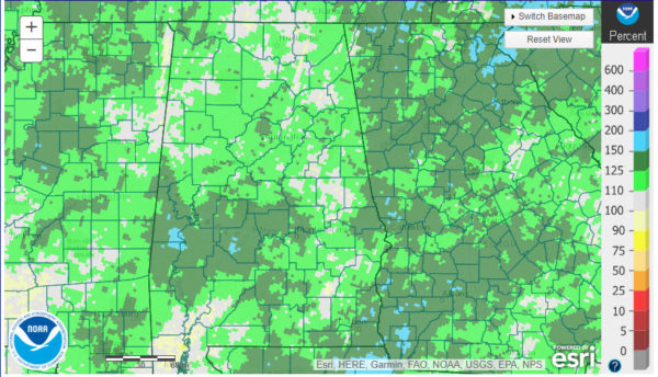
We continue to pile up a surplus for the year. Birmingham is currently running about 6 and a half inches above normal over the past year. Here are Year to Date rainfall amounts expressed as a percentage of normal:
As you can see, all of the state except for parts of Mobile and Baldwin Counties are near or above normal for the year.
Dense fog advisories cover much of South Alabama. There is some patchy fog over North Central Alabama as well. Visibiliies are down to 2-3 miles at places like Jasper, Haleyville, Gadsden, and Albertville.
Temperatures are cool to start the day, mostly in the 40s, and we will only be in the 50s near and north of I-20 today, with some lower and middle 60s over South Central Alabama. Many spots will touch 70F or higher on Monday however.
The showers will move out this morning leaving most areas dry through the afternoon, although we can’t rule out a few showers.
Showers are possible overnight. Monday will be warm and breezy with showers and storms becoming likely. More rain and storms will be likely late Wednesday. Then we will dry out finally.
I will have the video posted by 8 a.m.
Category: Alabama's Weather, ALL POSTS


