Weather Xtreme Video: Dry For A While Today, But Rain Return Later This Evening
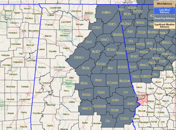
Much of Central Alabama is currently under a Dense Fog Advisory through 8:00 am this morning. Visibilities in these locations will drop to one-quarter mile or less. Be sure to slow down and drive with your low beams if you are out and about. Leave plenty of space between you and the vehicle in front of you.
We have a trough that has really dug in out in the southwest, while we are seeing some ridging over us. That means for us we’ll have a good bit of dry weather for much of the day, but some showers will start to move up from the south and make it into Central Alabama by later this evening. We’ll have a chance of scattered to numerous showers across the area for the evening through the overnight hours, but rainfall looks to be light at this point. We’ll have some sun before clouds move back in. Afternoon highs will be up in the lower 50s to the lower 60s across the area from northwest to southeast, with lows in the lower 40s to the upper 50s.
We’ll continue with a good chance of showers on your Sunday, but the rainfall will be light and it will not be an all day wash out. Skies will be cloudy and highs make it up into the lower 50s to the lower 70s across the area from northwest to southeast.
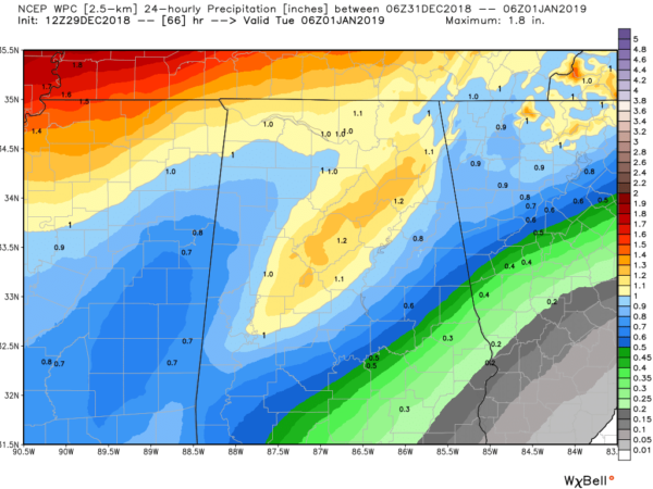
Monday, New Year’s Eve, will start off with scattered shower and maybe a clap of thunder or two, but heavier rain will become likely throughout the evening and into the pre-dawn hours on Tuesday. While the bad news is we most likely will be wet at the strike of midnight, but the good news is that rain will clear out of the area for a while during the afternoon and evening hours on Tuesday. Monday’s highs will be in the upper 60s to the mid-70s, falling back into the lower 50s to the mid-60s at midnight and only back up into the lower 50s to the upper 60s for Tuesday’s highs. As I mentioned earlier, most of the rain would fall on Monday and we can see the WPC is projecting up to 1.25 inches of rainfall for parts of Central Alabama.
The active pattern continues across Central Alabama as moisture will continue to stream in over the area. Shower activity will be scattered to start with early on Wednesday, but heavier rain looks to move in late on Wednesday evening and persist through nearly the entire day on Thursday. Wednesday’s highs will be in the lower 40s to the mid-50s across the area from northwest to southeast, with Thursday’s highs in the mid-40s to the mid-50s. Some locations in the extreme northwestern parts of the area could see the rain briefly change over to light snow or snow flurries early on Thursday morning on the backside of the rain shield.
Other than the cooler temperatures that we will be experiencing across Central Alabama, we shouldn’t have anything to complain about except having to work on Friday. We’ll have maximum sunshine and highs will be in the upper 40s to the mid-50s across the area from north to south.
Taking a brief step out into Voodoo Land, it looks like we are trending dry from Saturday the 5th through the morning hours of the 8th before a system moves in bringing what looks like our next rain chance. But that’s out there in Voodoo Land, so this will change. Temperatures are trending to be a little warmer than normal for the 5th through the 7th, with highs projected to be in the upper 50s to the lower 60s. I’ll take that.
Category: Alabama's Weather, ALL POSTS, Weather Xtreme Videos


