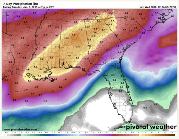
Extended Period of Very Wet Weather Ahead for Alabama
It looks like the weather pattern across the United States may flip as we head into January to one that favors cold weather in the eastern United States, including Alabama. That will be something to watch in coming days.
TODAY: Today will be a transition day across Alabama. The low cloud deck that has been over much of the area since yesterday will break up a bit today, allowing some sunshine to push temperatures into the lower 60s. You will notice an easterly or southeasterly wind as high pressure to the east flexes its muscles and low pressure deepens to the west.
WET IS THE WORD GOING FORWARD: As a deep trough sets up over the western states, a deep and broad southwesterly flow will set up from the Pacific and Mexico across the southern tier of states. This fast flow will carry numerous ripples or disturbances that will help enhance clouds and rain. In addition, a deepening low at the surface and in the lowest levels of the atmosphere will push moisture up and over the cool airmass from the east. This will lead to efficient rainfall starting by this evening over West Alabama and overspreading the area and increasing overnight. The rain will really increase in intensity Thursday night and end from the northwest Friday morning as a cold front tries to push through the area.
RAINFALL AMOUNTS: Rain amounts should be one-tenth of an inch tonight, and about three-quarters of an inch during the day on Thursday. Thursday night could see 2-3 inches of rainfall across the area with another inch before the rain comes to a temporary end on Friday. This will make total amounts around 3-5 inches before Friday afternoon. This could cause some local flooding.
WAS THAT THUNDER? Instability will be hard to come by during this evening, but there could be enough elevated instability to produce some thunder at times Thursday afternoon and night.

Rainfall amounts could run 5-7 inches across parts of Alabama between now and New Years Day. Flooding could result.
THE RAIN DOESN’T END: Despite a brief respite forecast for Friday night into early Saturday, rain will return during the day on Saturday as another disturbance passes through the flow. Rain could end again for a while on Sunday but should resume on Monday. Monday night looks wet unfortunately for New Year’s Eve celebrations. The European hints that there could be additional rain events Wednesday and Friday of next week! The Euro places 15-day rainfall amounts at around 6 inches, according to its ensemble mean.
GULF COAST WEATHER: An extended period of wet weather setting up for the beautiful beaches of Alabama and Northwest Florida as we head towards the New Year. Rain will begin late Wednesday and be a staple in the forecast right on through New Year’s Day. It won’t rain the whole of course, but there will be several bouts with showers and storms. Highs will touch 70F on Friday, but otherwise be in the mild 60s. Lows will be generally in the 50s and 60s.
Click here to see the Beach Forecast Center page.
WEATHERBRAINS: Go back and review the weather of 2018 with Greg Carbin from the Weather Prediction Center. Check out the show at www.WeatherBrains.com. You can also subscribe on iTunes. You can watch the show live at http://live.bigbrainsmedia.com/. You will be able to see the show on the James Spann 24×7 weather channel on cable or directly over the air on the dot 2 feed.
ON THIS DATE IN 1776: George Washington crossed the icy Delaware River and marched on Trenton in the midst of snow and sleet to surprise the British. Follow my weather history tweets on Twitter. I am @wxhistorian at Twitter.com.
Category: Alabama's Weather, ALL POSTS


