Nice Warm-Up Today; Rain Returns Tomorrow Night
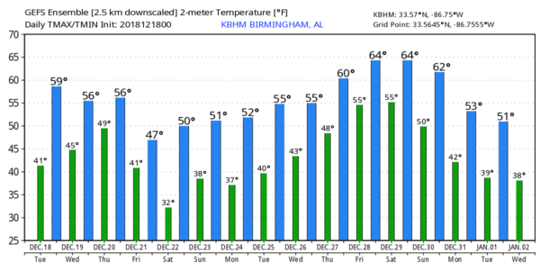
DRY AGAIN TODAY: Again this morning we have some patchy dense fog over parts of the state… especially the western counties… that will dissipate by mid-morning, and the sky will be mostly sunny today with a high between 58 and 63 degrees for most communities. Tonight will be fair and cold; we drop into the 30s early tomorrow morning.
WET WEATHER RETURNS: Tomorrow will feature a mix of sun and clouds with a high in the low 60s, but clouds will thicken late in the day ahead of a developing storm system to the west. Rain moves into the late late tomorrow night, and Thursday promises to be a wet day with periods of rain thanks to a surface low moving right over the state. No risk of severe storms, and probably not much thunder; temperatures will hold in the 50s. Then, Friday will be windy and colder with lingering light rain, mainly during the morning hours. Looks like we will be in the 40s most of the day Friday, and a north wind of 15-25 mph will make it feel colder. Rain amounts between tomorrow night and Friday should be in the one to one and a half inch range.
THE ALABAMA WEEKEND: The sky will clear Friday night, and the weekend will be rain-free. We expect a good supply of sunshine both Saturday and Sunday with highs generally between 55 and 60 degrees. Mornings will be rather chilly, and a freeze is likely early Saturday morning.
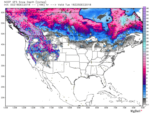
CHRISTMAS: Dry weather continues Monday and Tuesday with seasonal temperatures; the sky will be partly sunny with highs in the 50s and lows in the 30s. Need a White Christmas? Try the northern Rockies, or areas near the Canadian border. Much of the U.S. will be snow-free this year.
REST OF NEXT WEEK: Rain returns later in the week on Thursday, and possibly Friday as a complex storm over the western U.S. move eastward; see the Weather Xtreme video for maps, graphics, and more details.
ON THIS DATE IN 1944: Typhoon Cobra, also known as the Typhoon of 1944 or Halsey’s Typhoon (named after Admiral William “Bull” Halsey) was the United State Navy designation for a tropical cyclone that struck the Task Force 38 in the during World War II in the Pacific. The typhoon was first observed on December 17 as it surprised a fleet of ships in the open waters of the western Pacific Ocean. Sustained winds associated with the storm were up to 100 mph with gusts to 140 mph. On December 18, the small but violent typhoon hit the Task Force while many of the ships were attempting to refuel. Due to the extreme seas and winds, three destroyers capsized and went down with practically all hands, while a cruiser, five aircraft carriers, and three destroyers suffered serious damage. Approximately 790 officers and men were lost or killed with another 80 injured.
WEATHER BRAINS: Don’t forget you can listen to our weekly 90 minute show anytime on your favorite podcast app. This is the show all about weather featuring many familiar voices, including our meteorologists here at ABC 33/40.
BEACH FORECAST: Click here to see the AlabamaWx Beach Forecast Center page.
CONNECT: You can find me on all of the major social networks…
Facebook
Twitter
Instagram
Pinterest
Snapchat: spannwx
I have a weather program this morning at Wilson School in Lauderdale County… look for the next Weather Xtreme video here by 4:00 this afternoon. Enjoy the day!
Category: Alabama's Weather, ALL POSTS, Weather Xtreme Videos


