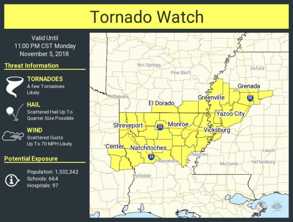
Tornado Watch Issued for Parts of Texas, Louisiana, Arkansas, and Mississippi
The first Tornado Watch of this severe weather event has been issued out to our west for the northern parts of Louisiana, extreme southeastern Arkansas, west-central Mississippi, and parts of eastern Texas. The watch is set to expire tonight at 11:00 pm CST. Winds in excess of 70 MPH, scattered hail up to quarter size, and a few tornadoes are possible. Here is the text from the Storm Prediction Center…
URGENT – IMMEDIATE BROADCAST REQUESTED
Tornado Watch Number 422
NWS Storm Prediction Center Norman OK
405 PM CST Mon Nov 5 2018
The NWS Storm Prediction Center has issued a
* Tornado Watch for portions of
Extreme southeastern Arkansas
Northern Louisiana
West central Mississippi
Extreme east central Texas
* Effective this Monday afternoon and evening from 405 PM until 1100 PM CST.
* Primary threats include…
A few tornadoes likely with a couple intense tornadoes possible
Scattered damaging wind gusts to 70 mph likely
Scattered large hail events to 1 inch in diameter possible
SUMMARY…Warm sector showers/thunderstorms will gradually strengthen from east Texas into northern Louisiana as the low levels continue to warm and moisten. The storm environment will become more favorable for supercells with tornadoes through the evening, when a strong tornado or two will be possible. Some eventual upscale growth into clusters and line segments is possible tonight, with an increasing threat for damaging winds as the storms spread into Mississippi.
The tornado watch area is approximately along and 70 statute miles east and west of a line from 15 miles south southwest of Natchitoches LA to 30 miles northeast of Greenville MS.
Category: ALL POSTS, Severe Weather


