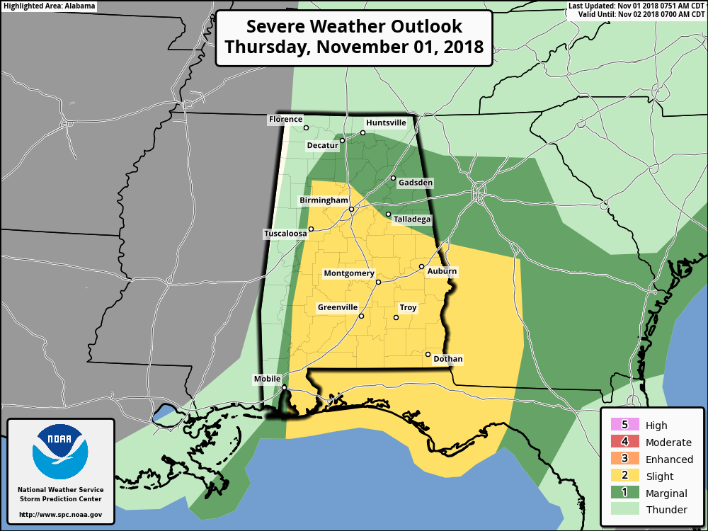
SPC Increases Slight Risk For Severe Storms For Today
From the Storm Prediction Center…
The main threat for severe weather today should be with damaging gusts and a few tornadoes, in a band of thunderstorms crossing parts of Alabama, Georgia and the Florida Panhandle.
A prefrontal band of strong-severe thunderstorms is expected to continue to pose a threat for sporadic damaging gusts and a few tornadoes as it moves eastward across the outlook area, this morning into parts of the afternoon.
Recent lightning and radar-reflectivity trends have indicated a general lessening of organization from north to south, with a consolidation of lightning production nearer to the coast. This is consistent with the weak lapse rates evident in the 12Z BMX sounding, and southward increase in theta-e in the warm sector, with surface dew points decreasing eastward. Theta-e advection in the warm sector, and diffused diabatic heating under the anvil canopy over land, will lead to a slight increase in buoyancy in support of slight to marginal severe-wind and tornado potential across the outlook area through the afternoon, amidst large low-level and deep-shear vectors. Late this afternoon into the evening hours, the prefrontal convection should encounter weakening of both low-level lapse rates and convergence over portions of southern GA and the eastern FL Panhandle. Accordingly, the severe probabilities should diminish eastward and with time from mid/late afternoon into evening, though isolated damaging gusts or a tornado cannot be ruled out amidst favorably strong deep shear.
LATER THIS AFTERNOON AND INTO THE EVENING HOURS
A narrow, relatively shallow band of convection also may form this afternoon along the cold front farther northwest and west over portions of OH, central/eastern KY, middle-eastern TN, and AL, where low-level lift will be maximized near and south of the surface low. Strong/isolated damaging gusts cannot be ruled out as this activity moves eastward to northeastward, but severe potential currently appears too conditional and isolated for a categorical outlook. This activity will be embedded within strong deep-layer wind fields ahead of the synoptic trough, but also, very weak surface-based instability, with air-mass recovery very uncertain behind the morning convective/precip band. Forecast soundings suggesting MLCAPE staying under 300 J/kg in most areas north of AL, and weakening/more-shallow lift with southern extent over AL. If mesoscale trends show boundary-layer recovery and/or frontal lift more robust than currently expected, some parts of this corridor may need to be included in a marginal wind area in a later update.
Category: Alabama's Weather, ALL POSTS
About the Author (Author Profile)
Scott Martin is an operational meteorologist, professional graphic artist, musician, husband, and father. Not only is Scott a member of the National Weather Association, but he is also the Central Alabama Chapter of the NWA president. Scott is also the co-founder of Racecast Weather, which provides forecasts for many racing series across the USA. He also supplies forecasts for the BassMaster Elite Series events including the BassMaster Classic.Subscribe
If you enjoyed this article, subscribe to receive more just like it.


