Three Scenarios – Three Very Different Sets of Coastal impacts
Famed North Carolina TV meteorologist Greg Fishel recently said something to the effect of “Don’t look at the forecast track, that’s where it’s not going.” He said that tongue in cheek of course, but no forecast track ever seems to be perfect. What we have is a cone of possible forecast outcomes that shrinks as the storm gets closer to the coast, following the average track forecast error. The hurricane could go right down the middle, on the left side of the cone or on the right side of the cone. Here are three scenarios, based on the official forecast thinking, a left moving storm and a right moving storm.
Unfortunately, residents have to prepare for all three impacts, since they are all reasonable forecast possibilities. The folks that get missed will have dodged a bullet. The impacted areas will be ready for whatever comes their way.
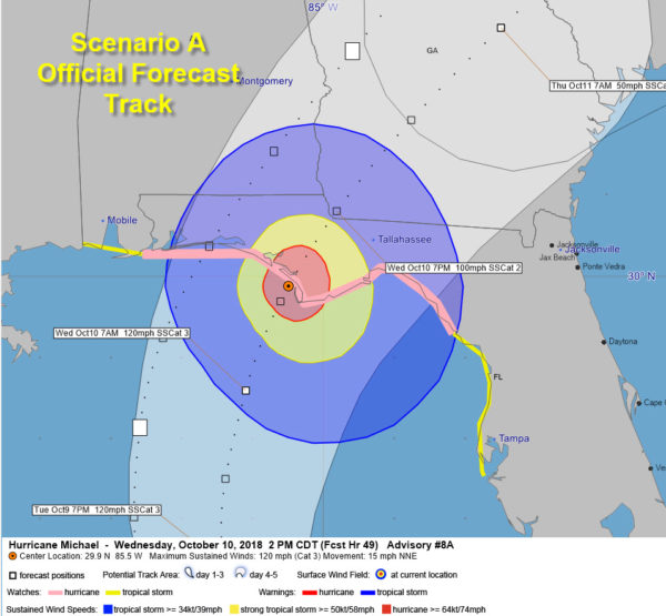
SCENARIO A – OFFICIAL TRACK
LANDFALL JUST SOUTH OF PANAMA CITY – 2PM CDT WEDNESDAY
…Tropical storm force winds arrive in the Panama City, Apalachicola and St. George Island areas around 4 a.m. Wednesday.
…Tropical storm force winds would overspread the coast from Navarre Beach through Fort Walton and Destin to Tarpon Springs through the day.
…Strong tropical storm force winds (58 mph or greater) would arrive on the coast from the 30A Beaches to south of Tallahassee starting as early as 9 a.m. Wednesday.
…About four hours of hurricane force winds would impact areas around Panama City, Apalachicola and St. George Island starting just before noon.
…This scenario would bring strong tropical storm force winds to Tallahassee, but a minor variation to the left or right would bring hurricane force winds to Florida’s capital city.
…This scenario would produce a devastating storm surge of 8-12 feet from Panama City through the Florida Big Bend area as far south as Crystal River.
…Over the Panhandle west of Panama City, the surge would be 5-8 feet east of Destin to Panama City, with 2-4 along the beaches from Pensacola to Destin.
…Tornadoes would be possible in the Florida Big Bend area, Panhandle and southeast Alabama and Southwest Georgia.
…5-10 inches of rain would fall near and to the east of the center.
…Heavy rains of 2-5 inches would also impact areas from Fort Walton and Destin east to the 30A Beaches, up into Southeast Alabama.
…Tropical storm force winds would affect Southeast Alabama with winds greater than 50 mph over the extreme southeastern corner of the state.
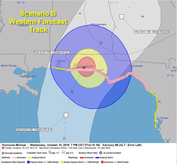
SCENARIO B – LANDFALL NEAR FORT WALTON BEACH – 7PM CDT WEDNESDAY
…Tropical storm force winds arrive on the Alabama and Northwest Florida Coast around 8 am Wednesday, first in the Pensacola/Perdido Key areas, and spreading onshore over the next few hours as far west as Pascagoula MS and as far east as St. Marks on Apalachee Bay.
…The Alabama coast would have several hours of tropical storm force winds under this scenario.
…Strong tropical storm force winds would begin in the Navarre, Fort Walton and Destin areas around 2 p.m. with hurricane force winds over about a 40 mile wide area for about four hours including Navarre, Fort Walton and Destin starting between 3-4 p.m.
…Winds would start diminishing along the Alabama coast between 8-11 p.m.
…Panama City and the Beaches along 30A would see several hours of tropical storm force winds, ending around 2 a.m. Thursday.
…Winds would drop below tropical storm force by 11 p.m. in Destin and Fort Walton.
…Areas of Southeast Alabama east of a line from Andalusia to Phenix City would see gusts to hurricane force and significant wind damage, including widespread power outages.
…This scenario would produce a devastating storm surge of 8-12 feet from Fort Walton through the Beaches of 30A to Panama City.
…6-8 feet of surge would affect the coastline through Apalachee Bay and the Big Bend area of Florida.
…2-4 feet of surge would impact the Alabama coast over to Navarre.
…5-10 inches of rain would fall near and to the east of the center from Destin/Fort Walton through the beaches of 30A.
…The Alabama Coast, Pensacola, Navarre and Panama City/Apalachicola would see 2-5 inches of rain.
…Heavy rains of 2-5 inches would also impact areas from Fort Walton and Destin east to the 30A Beaches, up into Southeast Alabama.
…Tornadoes would be possible over the Florida Panhandle and South Alabama starting Tuesday night.
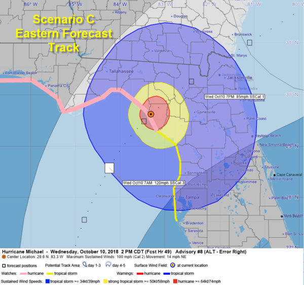
SCENARIO C – LANDFALL NEAR CROSS CITY – 2 PM CDT WEDNESDAY
…Tropical storm force winds would begin affecting areas from Panama City to Tampa Bay between midnight and 3 a.m. Wednesday.
…Strong tropical storm force winds of 58 mph or more would affect areas from Crystal River to Tarpon Springs between 9 a.m. and 5 p.m. with hurricane force winds from the Apalachee Bay to the mouth of the Suwanee River between noon and 3 p.m. CDT.
…This would produce a devastating storm surge of 8-12 feet from Indian Pass to Anclote Key in the Florida Big Bend, Apalachee Bay and west coast of Florida.
…West of there, through the Apalachee Bay to St. George Island, and Apalachicola, the surge could run 5-8 feet.
…Surge will run 2-4 feet east of Destin to St. George Island.
…Panama City, Apalachicola and St. George Island will experience tropical storm force winds.
…Tornadoes would be possible in the Florida Big Bend area and over the Florida Peninsula.
…5-10 inches of rain would fall near and to the east of the center.
…Heavy rains of 2-5 inches would also impact areas from the 30A beaches to Panama City.
…Under this scenario, no part of Alabama would experience tropical storm force winds.
PAY CLOSE ATTENTION TO YOUR LOCAL SPECIFIC FORECASTS from the National Weather Service and local officials.
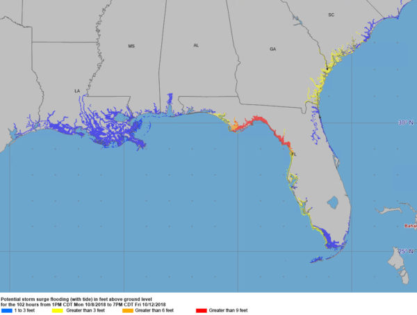
Here are surge forecasts based on the official forecast track:
As you can see, the surge impacts are going to be wide ranging.
So, three scenarios, and everything in between. That’s what coastal residents are up against. And the hurricane could still throw us some curveballs.
We will continue to refine the forecast and impacts as we go through time. I would expect to see hurricane warnings issued on the next advisory package which is coming up within the hour or by the 10 p.m. advisory tonight.


