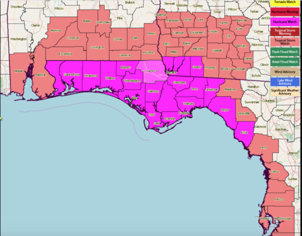
Hurricane, Tropical Storm Watches Issued
Tropical Storm Michael is nearly a hurricane early this morning. It is located 650 miles south of Panama City and has maximum sustained winds of 70 mph. It is expected to become a hurricane by this afternoon and a category two hurricane with top winds of 100 mph by late tonight. It is officially forecast to reach 110 mph, category two, late tomorrow night. There is a chance that it will reach category three, or major hurricane status, before landfall.
It will pass through the Yucatan Channel between Cuba and the Yucatan late tonight and into the southeastern Gulf of Mexico on a northerly course. It is moving north at 7 mph now and is expected to pick up some forward speed, to around 10 mph later today and 12 mph on Tuesday.
It will bring strong tropical storm force winds with perhaps some gusts to hurricane force to western Cuba tonight.
By Tuesday afternoon, it should begin a slow turn to the northeast ahead of an approaching trough.
Right now, you can find a model that will predict a landfall for any location between Mobile and Apalachicola. The official NHC track carries it just to the east of Panama City with landfall around sunset Wednesday evening. Landfall could occur anywhere between Pensacola and Cedar Key, Florida.
A hurricane watch has been issued along the Gulf Coast from the Alabama/Florida line to Suwanee River in Florida. A tropical storm watch is in effect for the Alabama coast and from the Suawnee River to Anna Maria Island, including Tampa Bay.
A storm surge watch is now in effect from Navarre, Florida to Anna Maria Island, including Tampa Bay. This includes Navarre, Fort Walton, Destin, all the 30A communities and Panama City. Storm surge may reach 4-7 feet for places like Sandestin, 30A and Panama City. From Apalachicola and St. George Island through the Florida Big Bend area to Crystal River, surge may reach 7-11 feet. 4-7 feet of surge could impact areas from Crystal River to the Anclote River. The Tampa Bay area could see 2-4 feet.
Tropical storm force winds could affect the Alabama and Northwest Florida Coasts as early at 6 p.m. Tuesday, so precautions will need to be finished by tomorrow.
And with any hurricane, expect surprises.


