What Do The Models Say About Florence
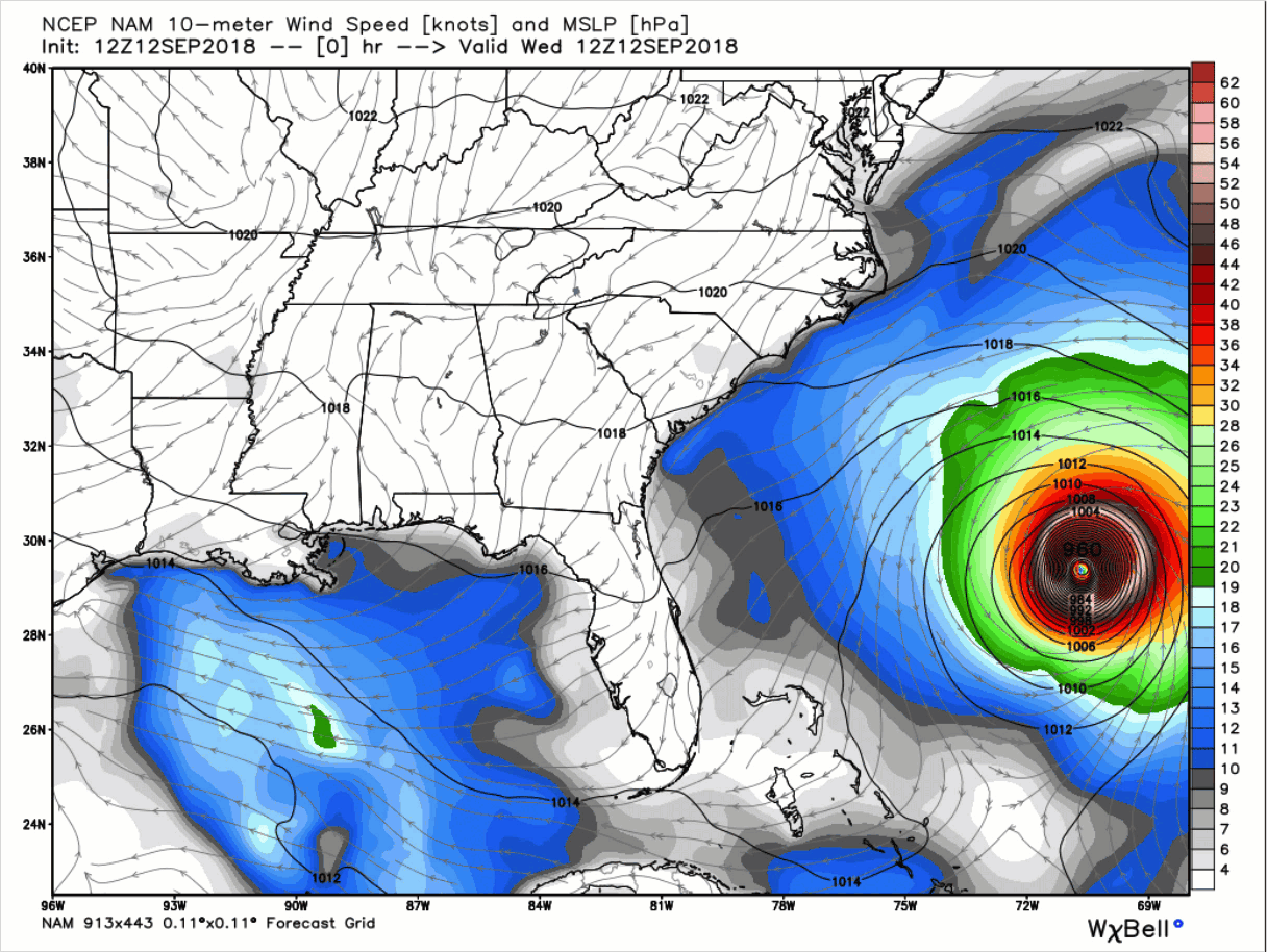
While each model run will have its differences, they will also have their similarities. Here is what the latest National Hurricane Center forecast track of Hurricane Florence shows:
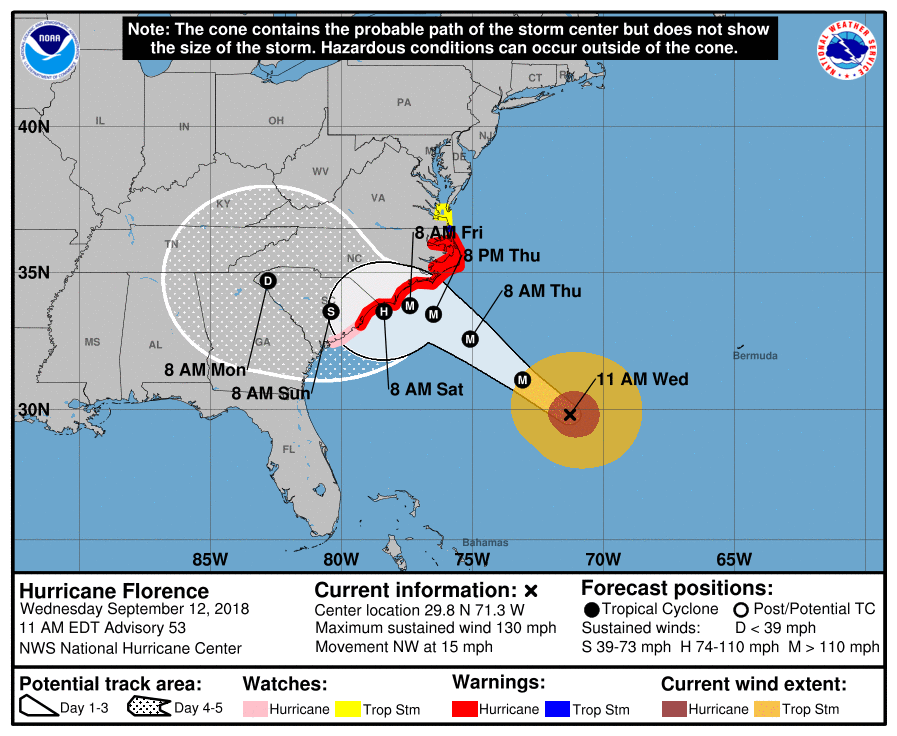
This shows that Florence will remain a major hurricane all the up until just before landfall where it weakens back into a category 1 or 2 storm, then moving onshore late Saturday morning or early Saturday afternoon just north of Myrtle Beach, South Carolina, and then moving west-northwest through the state by Monday morning.
Let’s see what the models hold for Florence…
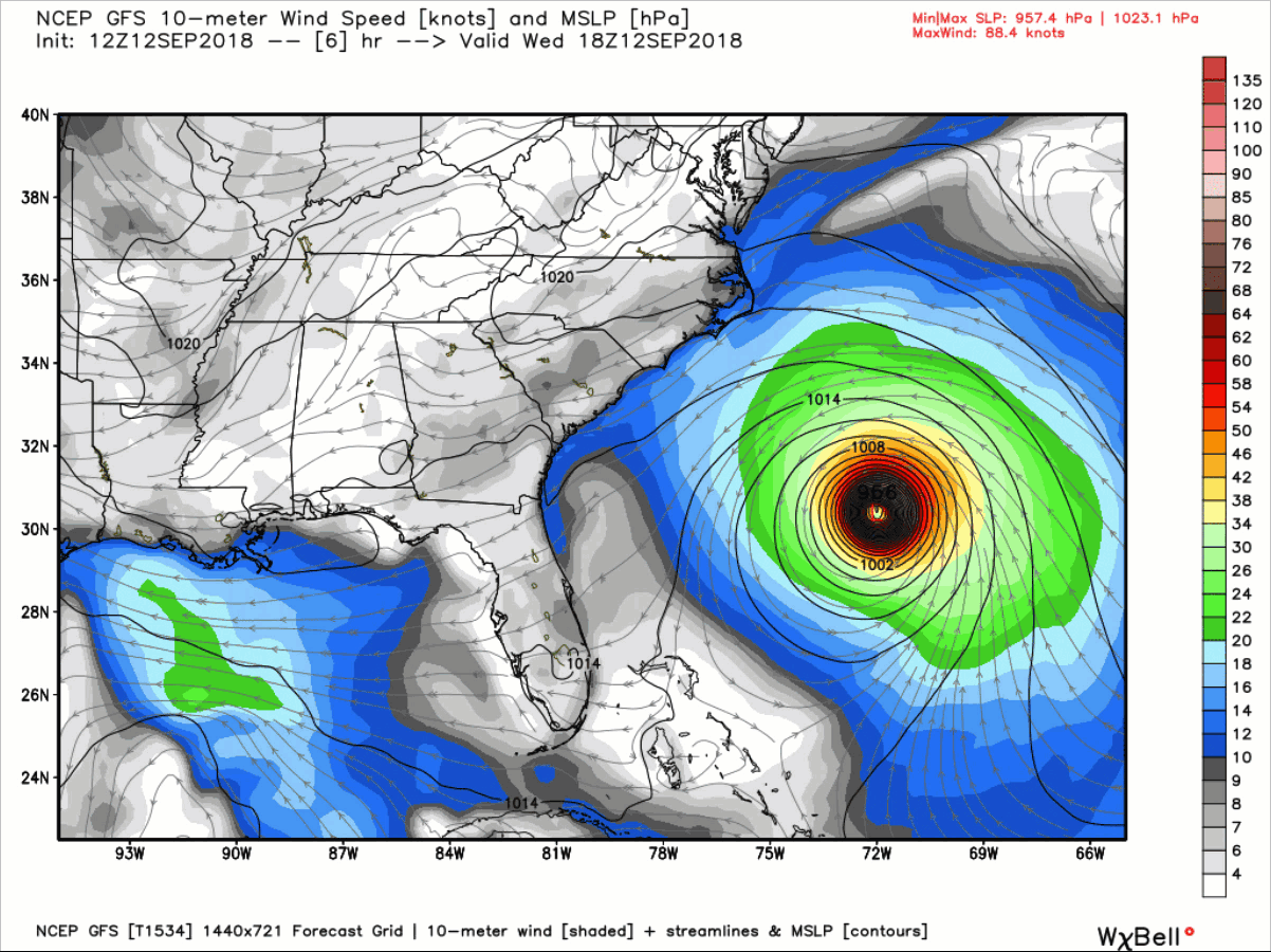
12z GFS
The center of Florence approaches the coast of southern North Carolina at 1:00 am CT on Friday morning before making landfall around Wilmington near 1:00 pm CT Friday as a category 1 hurricane. From there, it will drift just onshore southwestward down into the southeastern parts of South Carolina, before quickly changing directions to the west then to the north into western North Carolina and eastern Tennessee by early Monday morning and up into Kentucky and Ohio by Monday evening.
Rainfall amounts through 1:00 am Tuesday morning show much of the flooding rainfall confined mainly in the eastern parts of North Carolina and along the South Carolina coastline. Rainfall amounts will range from 2-40 inches.
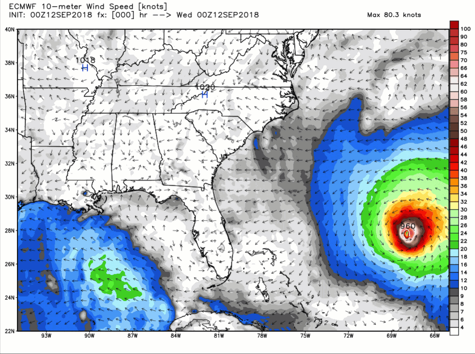
12z EURO
The center of Florence approaches the coast of southern North Carolina at 7:00 am CT on Friday morning before stalling out and meandering just offshore close to Wilmington as a strong category 2 or weak category 3 hurricane. It starts to slowly drift southwestward along the coast but offshore until Sunday morning when a westward motion occurs and landfall takes place later in the afternoon very close to Savannah as a strong category 1 or weak category 2 hurricane. From there, the center of Florence will start a curve pattern that will take it through West Georgia to eastern Tennessee to Central Virginia and eventually back over the Virginia coastline back to the Atlantic on next Thursday. After that, it will slowly drift southward and hang off the coast of South Carolina by the end of the 10-day model run.
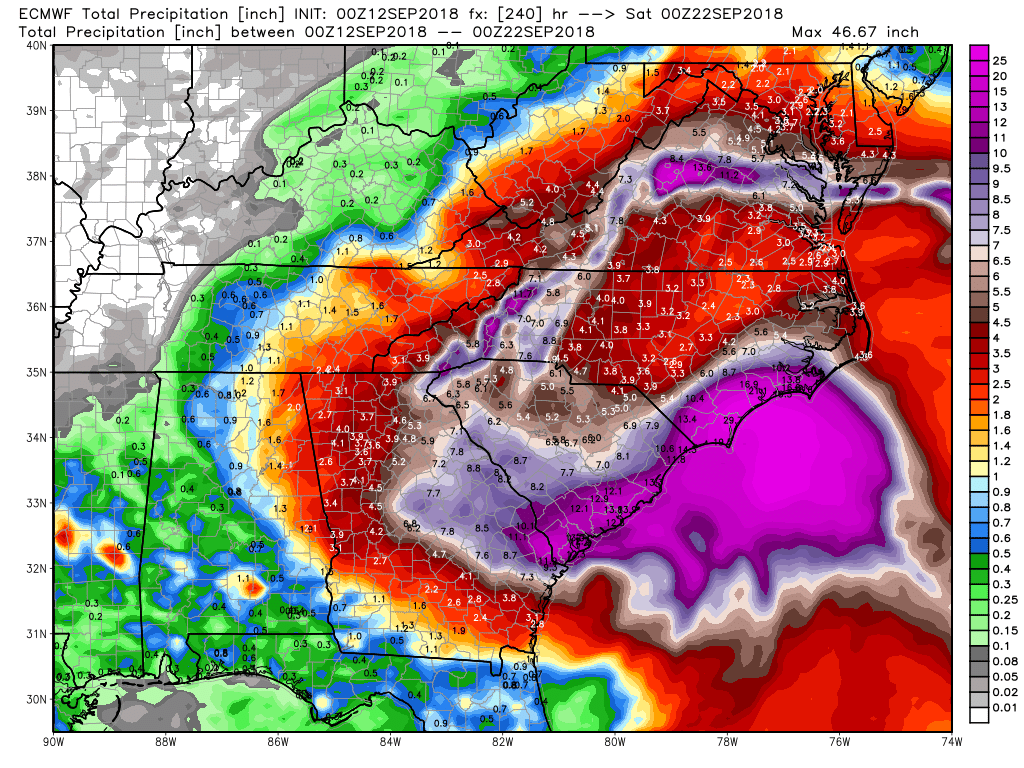
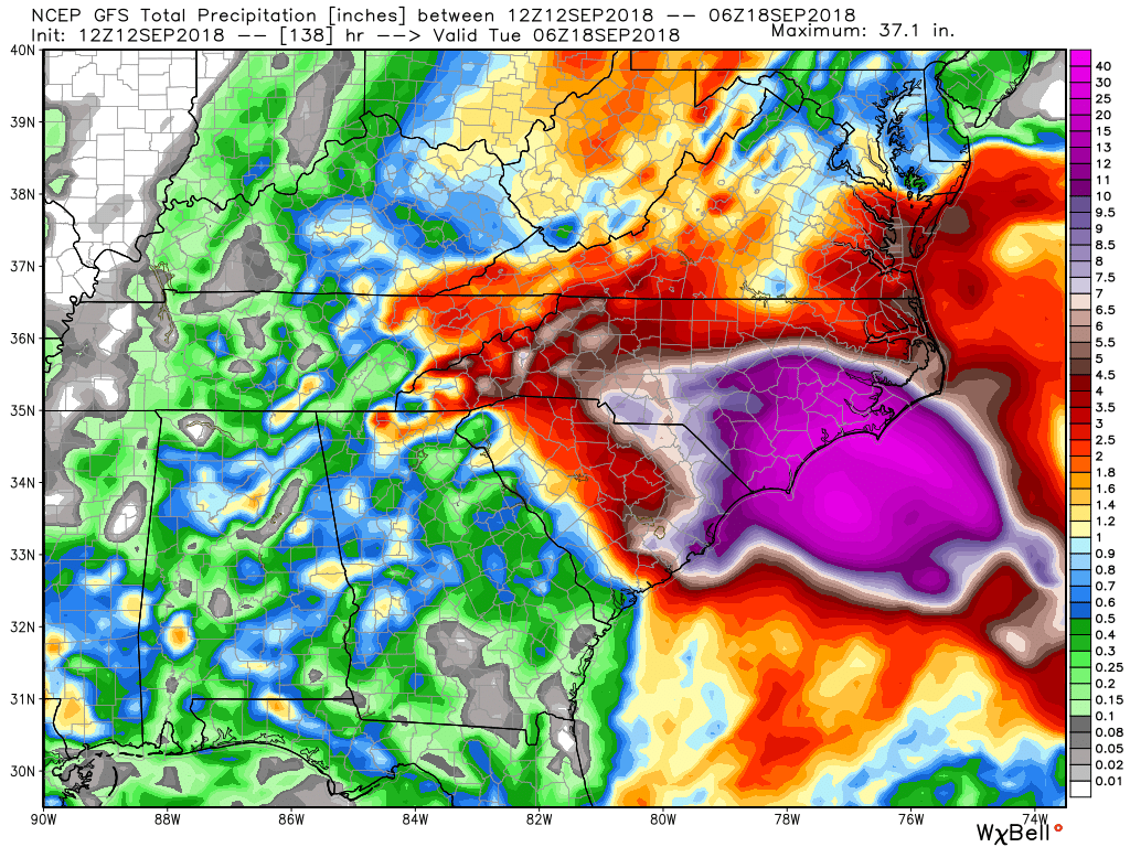
Rainfall amounts show to be heaviest along the coastline, but enhanced rainfall totals stretch well inland with this model run. Rainfall totals will range from 2-30 inches throughout the Carolinas, parts of Georgia and Tennessee, and up into the mid-Atlantic states. Some of the mountainous areas could see totals as high as 5-15 inches.
12z NAM-12K
Motion to the northwest stays at a constant speed through 1:00 pm CT Thursday as the eye of category 3 Hurricane Florence makes the approach to the North Carolina coastline. From here, forward motion slows dramatically and doesn’t make landfall until Friday morning around 10:00 am CT close to Wilmington, NC, as a category 1 hurricane. The eye will continue to meander around close to the same location while making multiple transitions on and offshore through the end of the 84-hour model run. On late Saturday evening, the center will be located just onshore near the NC/SC state line as a strong tropical storm.
Rainfall amounts range from 2 inches well inland to over 40 inches very close to the coastline of North Carolina. With this run, all of the flooding rainfall will be over the eastern parts of North Carolina.
So, as you can see, the models are in relatively close agreement with positioning, timing, and rainfall amounts… but with each model, there are some differences. These are also very similar with the National Hurricane Center forecast track.
Category: Alabama's Weather, ALL POSTS
About the Author (Author Profile)
Scott Martin is an operational meteorologist, professional graphic artist, musician, husband, and father. Not only is Scott a member of the National Weather Association, but he is also the Central Alabama Chapter of the NWA president. Scott is also the co-founder of Racecast Weather, which provides forecasts for many racing series across the USA. He also supplies forecasts for the BassMaster Elite Series events including the BassMaster Classic.Subscribe
If you enjoyed this article, subscribe to receive more just like it.


