Tropical Trio Update
Here is a Sunday morning look at the three tropical systems in the Atlantic basin…
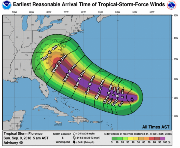
FLORENCE: This morning Florence is a tropical storm with sustained winds of 70 mph, located about 750 miles southeast of Bermuda. Conditions favor strengthening, and Florence should become a hurricane later today.
The new forecast track from NHC shows Florence, as a major, dangerous hurricane (category three or higher) near the southern coast of North Carolina late Thursday night/early Friday morning.
There is potential for tropical storm force winds (34 mph or higher) to reach the coast as early as Wednesday night…
IMPORTANT NOTES ON FLORENCE:
*The 5-day NHC track error is on average around 210 miles. So, do not focus on the center line, but the “cone of uncertainty”. That cone runs all the way from Hilton Head Island, SC to north of Hampton, Virginia.
*Given the uncertainty in track and intensity forecasts at those time ranges, it’s too soon to determine the exact timing, location, and magnitude of specific impacts on the U.S. Atlantic Coast.
*Interests along the U.S. East Coast, particularly from north Florida through North Carolina, should closely monitor the progress of Florence, ensure they have their hurricane plan in place, and follow any advice given by local officials.
*Large swells affecting Bermuda and portions of the U.S. East Coast will continue this week. These swells will result in life-threatening surf and rip currents.
*The hurricane is expected to slow down as it approaches the coast, and will have potential to produce serious flooding.
*No direct impact is expected in Alabama.
ISAAC: Tropical Storm Isaac is a lower latitude system, and is expected to become a hurricane tomorrow…
Based on the current forecast, Isaac will be near the Lesser Antilles in 4 to 5 days and interests there should monitor the progress of this system. It is too early to know if Isaac will enter the Gulf of Mexico, or threaten the U.S.
HELENE: This tropical storm in the eastern Atlantic is near the Cabo Verde Islands; it is expected to become a hurricane later today, But, this one will turn north and is no threat to North America.
We should note the climatological peak of the Atlantic hurricane season is September 10, so it makes perfect sense for the current active pattern.
Keep an eye on the blog for updates!
Category: Tropical


