Moist Air Parked Over Alabama Today
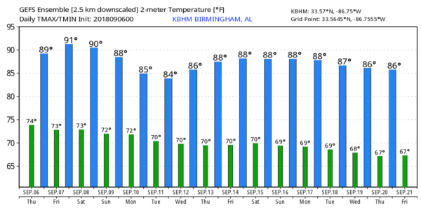
TROPICAL MOISTURE: Tropical Storm Gordon has pulled very moist, tropical air into Alabama, so we expect a number of scattered showers and thunderstorms around today and early tonight; chance of any one spot getting wet is around 60 percent. The sky will be occasionally cloudy, and the high will be in the mid to upper 80s. The average high for Birmingham on September 6 is 88.
TOMORROW AND THE WEEKEND: An upper high will strengthen across the state, so afternoon showers should be pretty isolated tomorrow and Saturday with rising heat levels. The sky will be partly sunny both days with a high around 90 degrees. Then, on Sunday, scattered showers and storms should be more numerous over the northern quarter of the state thanks to a surface front drifting down into Tennessee. With a mix of sun and clouds, we project a high in the upper 80s Sunday afternoon.
FOOTBALL WEATHER: For the high school games tomorrow night, just a small risk of a shower during the first half, otherwise mostly fair and very warm with temperatures falling though the 80s during the games.
Alabama hosts Arkansas State Saturday afternoon in Tuscaloosa at Bryant-Denny Stadium (2:30p CT kickoff); the sky will be partly to mostly sunny with just a small risk of a shower during the game. It will be a hot and humid day… kickoff temperature will be close to 90 degrees, falling back into the 80s by the fourth quarter.
Auburn will host Alabama State Saturday evening at Jordan-Hare Stadium (6:30p CT kickoff)… the sky will be mostly fair with only a slight risk of a shower during the first half. Temperatures will fall from near 86 at kickoff, into the upper 70s by the final whistle
UAB travels to Conway, South Carolina to take on Coastal Carolina Saturday evening (6:00p CT kickoff)… a shower or storm is possible during the first half of the game, otherwise it will be warm and humid with temperatures falling through the 80s during the game.
NEXT WEEK: The first half of the week look rather unsettled with scattered to numerous showers and storms each day thanks to a stalled front near the Alabama/Tennessee border. Highs will be in the 80s… see the Weather Xtreme video for maps, graphics, and more details.
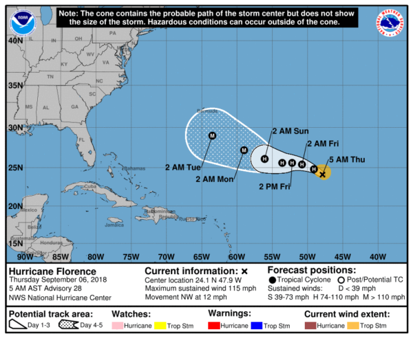
TROPICS: Hurricane Florence is in the Atlantic, for now far from land, with sustained winds of 115 mph. It should be south of Bermuda by early next week…
It is still too early to know if Florence will recurve into the Atlantic, or if it will directly impact the U.S. East Coast late next week. For now the mean of the global model ensemble members want to keep it a little offshore, but it will be a close call, and all on the U.S. Atlantic coast will need to keep an eye on this.
A well organized wave in the eastern Atlantic should become Tropical Storm Helene in coming days; it could very well impact the Leeward Islands in 5 days or so. Too early to know if this will be an issue for the Gulf of Mexico or North America.
And, another wave is just off the coast of Africa with some chance of development over the next few days as it moves to the west.
BEACH FORECAST: Click here to see the AlabamaWx Beach Forecast Center page.
WEATHER BRAINS: Don’t forget you can listen to our weekly 90 minute netcast anytime on the web, or on iTunes. This is the show all about weather featuring many familiar voices, including our meteorologists here at ABC 33/40.
CONNECT: You can find me on all of the major social networks…
Facebook
Twitter
Instagram
Pinterest
Snapchat: spannwx
I have a weather program this morning at Alabama Power in downtown Birmingham… look for the next Weather Xtreme video here by 4:00 this afternoon. Enjoy the day!
Category: Alabama's Weather, ALL POSTS, Weather Xtreme Videos


