Fairly Typical Labor Weekend Weather for Central Alabama; Watching the Gulf for Tropical Development

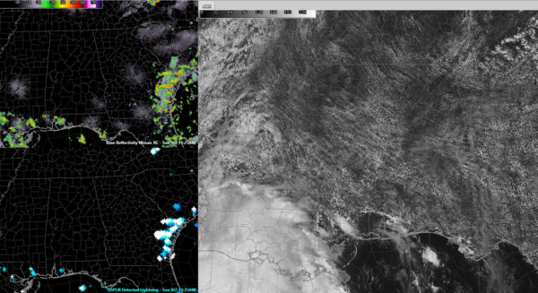
Satellite image on right showing fair weather cumulus across much of Alabama; left panels show rain over southeastern Louisiana, southern Mississippi, coastal Alabama and Northwest Florida. Only isolated lightning for now over these areas. Lots of storms over Coastal Georgia, South Carolina and Northeast Florida.
Today marks the beginning of meteorological fall, but you can’t tell it by the weather outside across Central Alabama. It is a hot and humid late summer afternoon. Showers and storms will be isolated at best today, thanks to high pressure centered over southwestern Virginia.
High temperatures will top out between 90-92F this afternoon. Overnight lows tonight will drop into the lower 70s.
As Ryan Stinnett says quite often, rinse and repeat this forecast again tomorrow. I love going back and watching the Super 8 home movies of Labor Days from my childhood in the 60s when my family would get together to barbecue, listen to baseball on the radio and enjoy the heat of a late summer day in Alabama. Tomorrow will look a lot like those past Labor Days weather wise.
By Tuesday, we will see a few more showers and storms as we track what should be then Tropical Depression Seven or Tropical Storm Gordon tracking south of the Northwest Florida coast.
By early Wednesday, the tropical storm will be making landfall somewhere over Southeast Louisiana, perhaps as far east as the Mississippi border. Rain chances should increase for areas west of I-65. rainfall amounts will range from 0.5 inches to one inch over western Alabama, decreasing to less than a quarter of an inch over eastern sections. You will sense the winds on Wednesday, with gusts over 20 mph at times.
We will remain on the “wetter” east side of the cyclone on Thursday, but rain chances will already be trending back down. Next weekend will feature scattered showers and storms with highs in the upper 80s and lows in the middle 70s. Humidity will be high.
Category: Alabama's Weather, ALL POSTS


