Mainly Isolated Storms Today and Labor Day
The surface high as well as the upper ridge remain situated over the Mid-Atlantic states keeping the weather across Central Alabama warm and humid. Showers and thunderstorms will continue to be possible driven by afternoon heating, but the deepest moisture along with the best chances for rain remains to our south.
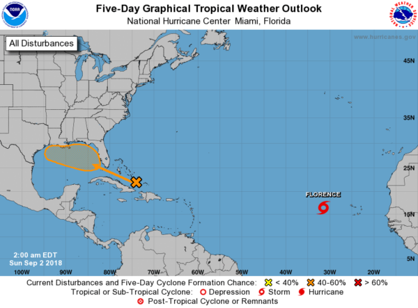
Tropics: Florence has shown continued strengthening as it moves away from the Cape Verde Islands. It will move over the far eastern Atlantic, far from land over the weekend and early next week. The storm is currently forecast to remain a tropical storm through the middle of the week.
A tropical wave approaching the Bahamas will move toward the Gulf of Mexico this week. NHC gives the disturbance a 40 to 60 percent chance of development over the next five days. The future course and development of this system will have a major impact on the forecast for Central Alabama. Right now model guidance suggests minimal impact as it moves into the northern Gulf and then into the Lower Mississippi River Valley as it circulates around the upper ridge off the Carolina coast. While there remains a good deal of uncertainty on the exact path and strength of this system, the GFS and ECMWF model guidance have come into very close agreement. This definitely qualifies as a stay tuned situation.
The upper air pattern will see the large upper ridge remain over the eastern US through weekend as it gradually shows signs of weakening. This keeps us on the edge of any excessive heat and also keeps us in fairly good moisture. This points pretty much to scattered showers and thunderstorms driven primarily by the heating of the day. We will maintain a close watch on the tropical wave coming across Florida and into the northwestern Gulf of Mexico during the first half of the week. The upper ridge should keep it away from Alabama.
High temperatures will remain within a couple of degrees of 90 for much of the week ahead with highs depending significantly on the impact of morning lows near 70.
By the end of the week, the upper ridge will weaken considerably as a trough moves across the Great Lakes and drags a front toward the Southeast US. With the presence of the front, we could see rain chances go up a good bit, but we are verging on voodoo country.
Looking out into voodoo country, the GFS suggests the development of a fairly deep trough over the eastern US by the 13th of September. This feature along with the upper ridge over the western US will stick around through the 16th of September. This pattern suggests no heat issues but could also be somewhat wet.
Beach Forecast: Click here to see the AlabamaWx Beach Forecast Center page.
WeatherBrains: Don’t forget you can listen to our weekly 90 minute netcast anytime on the web, or on iTunes. This is the show all about weather featuring many familiar voices, including our meteorologists here at ABC 33/40.
James Spann will have the next Weather Xtreme Video posted here on Monday morning. Being a holiday weekend, we will probably produce just one video. You can catch the latest forecasts on Monday and Tuesday morning as I sub for Meaghan Thomas on ABC 3340. Have a great day and Godspeed.
-Brian-
Category: Alabama's Weather, ALL POSTS, Weather Xtreme Videos


