Best Chance Of Storms South And West Of Birmingham Today
A FEW STORMS LATER TODAY: A drier airmass is over Northeast Alabama today, so showers should be very hard to find there. Best chance of scattered storms this afternoon will be from Birmingham south and west, where deeper moisture lingers. Otherwise, today will be a typical hot August day with a partly sunny sky and a high in the low 90s for most communities.
TOMORROW/WEDNESDAY: Moisture levels will rise over Northeast Alabama, so a few pop up storms are possible pretty much statewide on these two days, but they will be widely scattered, and mostly during the afternoon and evening hours. Chance of any one spot getting wet both days is about one in four, and the high will stay in the low 90s. A few spots could reach the mid 90s, especially over West Alabama.
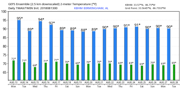
THURSDAY/FRIDAY: The ridge across the region will weaken, and as the air becomes more unstable, we should see a general increase in the number of scattered showers and thunderstorms. Chance of a storm for any given community is around 40 percent Thursday, and 60 percent Friday. The high Thursday will be around 90, but in the mid to upper 80s Friday with an increase in clouds and showers.
THE ALABAMA WEEKEND: Not much change; the sky will be occasionally cloudy with scattered to numerous showers and thunderstorms. Best chance of showers and storms will come from 1:00 until 11:00 p.m., and highs will remain in the mid to upper 80s.
NEXT WEEK: We will roll with the standard summer forecast for much of the week; partly sunny days with “scattered, mostly afternoon and evening showers and thunderstorms”. Highs will be close to 90… see the Weather Xtreme video for maps, graphics, and more details.
TROPICS: The Atlantic basin remains very quiet. A disturbance in the North Atlantic far from land is drifting south, it has only a 20 percent chance of development due to strong upper air winds.
ON THIS DATE IN 2004: Charley moved into the Florida Gulf Coast south of Tampa Bay near Punta Gorda with sustained winds of 150 mph, a strong category four hurricane. It was one of four hurricanes that made landfall, or had a direct impact on the Sunshine State that season. Charley was initially expected to hit further north in Tampa, and caught many Floridians off-guard due to a sudden change in the storm’s track as it approached the state. Along its path, Charley caused 10 deaths and $16.9 billion in damage to insured residential property, making it the second costliest hurricane in United States history at the time. Charley was a compact, fast-moving storm, which limited the scope and severity of the damage.
BEACH FORECAST: Click here to see the AlabamaWx Beach Forecast Center page.
WEATHER BRAINS: Don’t forget you can listen to our weekly 90 minute netcast anytime on the web, or on iTunes. This is the show all about weather featuring many familiar voices, including our meteorologists here at ABC 33/40.
CONNECT: You can find me on all of the major social networks…
Facebook
Twitter
Google Plus
Instagram
Pinterest
Snapchat: spannwx
Look for the next Weather Xtreme video here by 4:00 this afternoon… enjoy the day!
Category: Alabama's Weather, ALL POSTS, Weather Xtreme Videos


