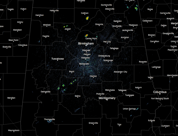
A Few Isolated Showers Out There: It’s The Midday Nowcast For Central Alabama
WEATHER CHECK AT 11:30 AM
Looking at the radar across Central Alabama, we do have a few isolated showers showing up, with the heaviest one at this point located over the Morris community in northern Jefferson County. Another brief but heavier shower is located over Hanceville in Cullman County. The rest of the activity is smaller, and all of it is moving very slowly to the south. The rest of the area has partly cloudy skies. Temperatures are in the upper 70s to the upper 80s, with the warm spot being Tuscaloosa at 88 degrees. Birmingham was sitting at 86 degrees.
WEATHER FOR THE REST OF YOUR FRIDAY
There is an inverted trough along the Gulf Coast will start to move northward during the afternoon hours, while the main trough over the southeast continues to weaken. With both of those scenarios combined, this will lead to most of the scattered shower and storm activity over the extreme southern and southeastern parts of Central Alabama, while the rest of the area will see a small chance of a few isolated to scattered showers and storms. Skies will be partly to mostly cloudy with afternoon highs in the mid-80s to the lower 90s. For the evening and throughout the late night and overnight hours, nearly all of the activity should diminish by 10:00 PM or so, but one or two stray showers may linger a few hours later. Lows will be in the upper 60s to the lower 70s.
THE WEEKEND AHEAD
High pressure that is located off of the east coast will bully any remnants of the trough out of the area, and we’ll transition into ridging over the southeast as that high moves westward. This will put us back into a more typical weather pattern for early August across Central Alabama. We’ll still have a good bit of moisture to deal with on Saturday, which will keep our afternoon shower and storm chances around 40-50%. Highs will be in the upper 80s to the lower 90s. The air mass will be a little drier on Sunday, bringing our rain chances down to 30-40% throughout the area. Sunday’s highs will be in the upper 80s to the lower 90s. Any place that sees rain will possibly have to put up with the development of patchy fog during the late night and overnight hours.
ON THIS DAY IN WEATHER HISTORY
1989 – Thunderstorms representing what remained of Hurricane Chantal drenched Wichita, KS, with 2.20 inches of rain in four hours during the early morning. Thunderstorms developing in Minnesota produced wind gusts to 85 mph at Baudette during the afternoon, and softball size hail at Lake Kabetogama, during the evening. Jamestown, ND, reported a record hot afternoon high of 103 degrees.
BEACH FORECAST CENTER
Get the latest weather and rip current forecasts for the beaches from Fort Morgan to Panama City on our Beach Forecast Center page. There, you can select the forecast of the region that you are interested in.
WE’RE HAVING A RECORD-BREAKING YEAR… ADVERTISE WITH US TODAY!
Don’t miss out! We have enjoyed nearly 13 MILLION page views on AlabamaWx.com since the start of 2018. We can customize a creative, flexible and affordable package that will suit your organization’s needs. Contact Bill Murray at (205) 687-0782.
E-FORECAST
Get the AlabamaWx Weather Blog’s Seven-Day Forecast delivered directly to your inbox by email twice daily. It is the most detailed weather forecast available in Central Alabama. Subscribe here… It’s free!
WEATHERBRAINS
Don’t forget you can listen to our weekly 90 minute netcast anytime on the web at WeatherBrains.com or on iTunes. This is the show all about weather featuring many familiar voices, including the meteorologists at ABC 33/40.
Category: Alabama's Weather, ALL POSTS


