Storms Get an Early Start This Morning
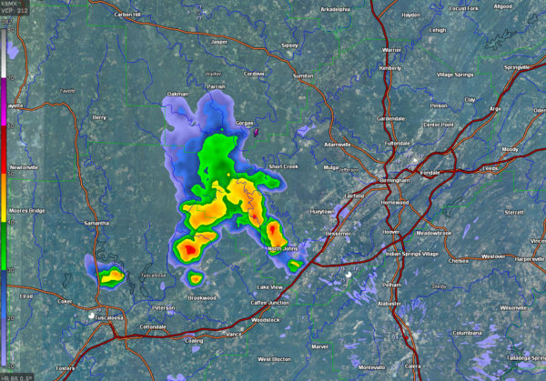
RADAR CHECK AT 8:30
Radar indicates strong, but not severe, storms across parts of southern Walker, northeastern Tuscaloosa, and extreme western Jefferson Counties. They are well west of Birmingham, well northwest of Tuscaloosa and well south of Jasper and Sumiton.
They will affect places like Kellerman, Abernant and Oak Grove as they slide slowly south-southeast. The storms have lightning, heavy rain and some gusty winds.
They will move toward Brookwood, Woodstock and Lake View in the I-59 Corridor, but do appear to be slowly weakening.
Earlier, they dumped 1-2 inches of rain in less than an hour in places south and southwest of Gorgas near the Warrior River.
They appear to be forming in a moisture axis that lies in along a northwest to southeast axis from Marion and Lamar Counties through Tuscaloosa, Bibb and Chilton Counties on into the Montgomery and Eufaula areas. In this axis precipitable water values are over 2 inches, hence the heavy rain.
More showers and storms will start forming before noon across the entire area. They will be scattered but fairly numerous and will be equal opportunity storms in that they won’t favor one area today. Lots of folks will be out playing and enjoying summer today, so keep an eye to the sky and look for developing dark clouds. When you see that, you know a storm is forming. And lightning can begin well before the rain really gets started, so try to be in a shelter before that first lightning strike happens. And when thunder roars, go indoors.
Until the storms provide some cooling relief, it will be hot. Highs today will be in the lower to middle 90s. When combined with dewpoints in the 72-79F range, heat index values will be in the 105-108F range. Take it easy if you are spending time outside. Heat advisories are posted for much of Northwest, West Central and South Central Alabama.
Category: Alabama's Weather, ALL POSTS


