At Midday, This Summer Weather Is Hot, Hot, Hot!
CONDITIONS ACROSS CENTRAL ALABAMA AT 11:30 AM
First of all, let me wish my oldest daughter, Charlotte, a Happy 16th Birthday! We are about to head down to her favorite Chinese restaurant to enjoy some of her favorite dishes, followed by a superhero movie at a theater soon after.
As of 11:30 AM, we have mostly clear to partly cloudy skies throughout Central Alabama with only one very small isolated shower located just to the west of Heflin. The rest of the radar is dry at this point. Temperatures are already getting close to the “hot” range, with mid-80s to the upper 80s showing up on the latest observations. Birmingham was at 86 degrees. Unfortunately, heat index values are already reading in the 93-103 degree range. You know what to do… if you get hot, go inside and cool off and drink plenty of cold water.
WEATHER FOR THE REMAINDER OF YOUR TUESDAY
This afternoon will be hot, hot, hot! Skies throughout the day will be partly cloudy and we’ll only have a slight chance of an isolated afternoon shower or storm throughout much of the area, while a few scattered storms are possible in the west and southwestern parts of Central Alabama (Hamilton to Tuscaloosa to Troy and points south). Afternoon highs will reach the lower to mid-90s, while one or two locations may hit the upper 90s. Skies will be mostly cloudy for the late night and overnight hours, with a very small risk of a shower or two over the extreme east and southeastern corner of the area (Anniston to Clanton to Selma and points south). Lows will be in the lower to mid-70s.
HAPPY INDEPENDENCE DAY
It will be hot as a firecracker on the 4th of July, as high temperatures will once again make it back up into the lower to mid-90s. Skies will be partly cloudy throughout the day and we’ll have a chance of isolated showers and storms in the northern half of Central Alabama, with a chance of scattered showers and storms in the southern half. Skies will begin to clear out some for the evening hours, but we can expect partly cloudy skies with a very small chance of a scattered shower or storm for the big fireworks extravaganza at Red Mountain, with the temperature in the upper 70s. Overnight lows will only drop down into the lower 70s.
AN UPDATE ON THE TROPICS
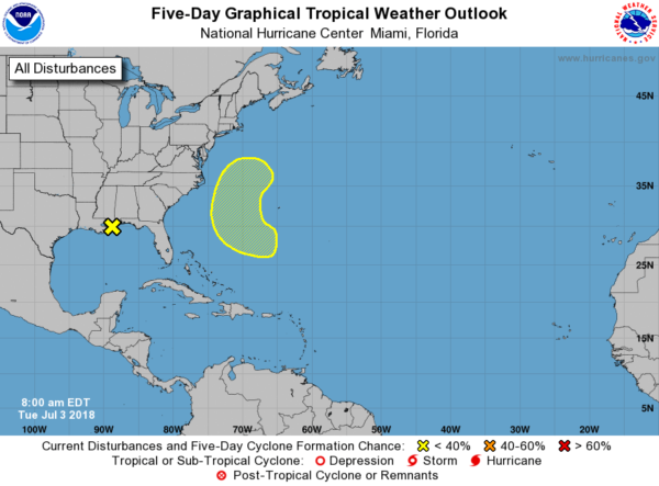
There are two areas of concern that are showing up on the National Hurricane Center Tropical Weather Outlook map. The first area of concern is an upper low that is bringing showers and thunderstorms to the northern Gulf Coast. This disturbance is moving inland over southeastern Louisiana and heavy rainfall will be possible over southern Louisiana and southeastern Texas. No tropical development is expected.
The second area of concern is located off the coast of the US just southwest of Bermuda, as a non-tropical low is expected to form with an associated upper-level trough. It has a very small chance of development (20% chance) after it forms and moves north or northwestward, but by Sunday a front is expected to sweep in and stunt the chances of development. No threat to the US.
ON THIS DAY IN WEATHER HISTORY
1987 – Lightning struck and killed three men playing golf on a course near Kingsport TN. The three men had sought shelter from the rain under a tall tree on a small hill.
BEACH FORECAST CENTER
Get the latest weather and rip current forecasts for the beaches from Fort Morgan to Panama City on our Beach Forecast Center page. There, you can select the forecast of the region that you are interested in.
WE’RE HAVING A RECORD-BREAKING YEAR… BE SEEN WITH ALABAMAWX.COM!
Don’t miss out! We have enjoyed over 11.7 MILLION page views on AlabamaWx.com since the start of 2018. We can customize a creative, flexible and affordable package that will suit your organization’s needs. Contact Bill Murray at (205) 687-0782.
E-FORECAST
Get the AlabamaWx Weather Blog’s Seven-Day Forecast delivered directly to your inbox by email twice daily. It is the most detailed weather forecast available in Central Alabama. Subscribe here… It’s free!
WEATHERBRAINS
Don’t forget you can listen to our weekly 90 minute netcast anytime on the web at WeatherBrains.com or on iTunes. This is the show all about weather featuring many familiar voices, including the meteorologists at ABC 33/40.
Category: Alabama's Weather, ALL POSTS


