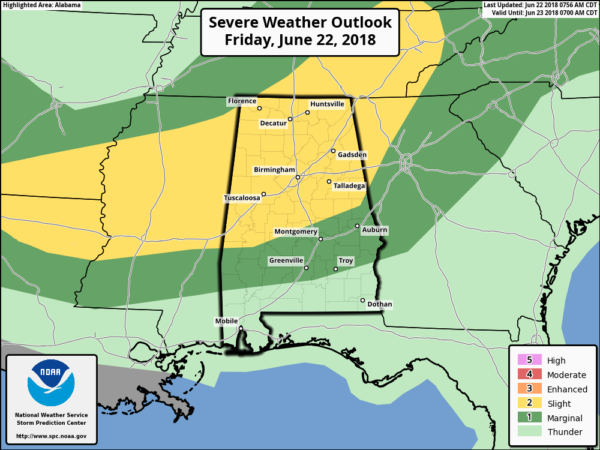
A Batch Of Storms Moving In At The 11:00 AM Update
Radar check at 10:45 AM shows that all of Central Alabama is virtually dry at this point, but a batch of showers and thunderstorms will be moving into the western parts of Franklin, Marion, and Lamar counties within the next 30-60 minutes. There is some heavy rainfall and dangerous cloud-to-ground lightning, but storms are not strong to severe at this time.
NWS Huntsville just stated a few minutes ago that the stratus cloud deck had kept much of the area stable throughout the morning so far, but destabilization is starting to occur in the northwestern parts of the state.
Much of North and Central Alabama continues to be defined in a Slight Risk of severe storms for today with the exception of areas south of a line from Thomaston to Selma to Dadeville to Roanoke. Those locations are in a Marginal Risk for severe storms.
Timing for strong to severe storms throughout the are will be from now until 10:00 PM tonight. The main threats will be from damaging straight line thunderstorm winds of up to 60 MPH, very heavy rainfall, and dangerous cloud-to-ground lightning. There is also much smaller threat of a couple of isolated tornadoes.
Other than the storms that will be moving into the state very shortly, additional storms are expected to develop stating early in the afternoon as the atmosphere continues to destabilize. There will be enough helicity that some rotating storms are possible, so a brief tornado or two cannot be ruled out. Damaging winds will continue to be the main threat throughout the day and into the evening.
Cloud cover in the southwestern parts of Central Alabama along with high clouds moving in from the west may limit surface instability some, but we still believe severe storms will be possible.
Today’s highs should top out in the mid-80s to the lower 90s. Storms will calm down later tonight, but a few storms could persist into the late night and through some of the overnight hours. Severe weather is not expected at that time. Lows will be in the lower to mid-70s.
We’ll keep you posted throughout the day with updates. Remember that if any warnings or advisories are issued, they will be posted to the blog immediately after the NWS issues them. Check back often, and follow us on Facebook and Twitter.
AN UPDATE ON THE TROPICS
The North Atlantic, Caribbean Sea, and the Gulf of Mexico is calm at this time, and no new tropical cyclones are expected throughout the next 5 days.
ON THIS DAY IN WEATHER HISTORY
1972 – Hurricane Agnes deluged Pennsylvania and New York State with torrential rains resulting in the most costly flood in U.S. history. In the Middle Susquehanna Valley of Pennsylvania, 24 hour rainfall amounts were generally 8 to 12 inches, with up to 19 inches in extreme southwestern Schuylkill County. At Wilkes-Barre, PA, the dike was breached destroying much of the town. Flooding resulted in 117 deaths and 3.1 billion dollars damage.
1981 – A young woman from Lubbock, TX, was struck by lightning. The bolt of lightning struck just above her right shoulder near her neck, and passed right to left through her body, tearing her warm-ups, causing her tennis shoes to explode, and lifting her two feet into the air.
BEACH FORECAST CENTER
Get the latest weather and rip current forecasts for the beaches from Fort Morgan to Panama City on our Beach Forecast Center page. There, you can select the forecast of the region that you are interested in.
WE’RE HAVING A RECORD-BREAKING YEAR… ADVERTISE WITH US TODAY!
Don’t miss out! We have enjoyed over 11 MILLION page views on AlabamaWx.com since the start of 2018. We can customize a creative, flexible and affordable package that will suit your organization’s needs. Contact Bill Murray at (205) 687-0782.
E-FORECAST
Get the AlabamaWx Weather Blog’s Seven-Day Forecast delivered directly to your inbox by email twice daily. It is the most detailed weather forecast available in Central Alabama. Subscribe here… It’s free!
WEATHERBRAINS
Don’t forget you can listen to our weekly 90 minute netcast anytime on the web at WeatherBrains.com or on iTunes. This is the show all about weather featuring many familiar voices, including the meteorologists at ABC 33/40.
Category: Alabama's Weather, ALL POSTS


