Summertime Weather Means Daily Showers/Storms
* * * No Weather Xtreme Video this morning due to safety fair at Mercedes in Vance * * *
It was certainly active across Alabama yesterday with numerous thunderstorms and flooding issues especially in the Birmingham metro area. But the radar is clear this morning. Clouds were noted along the Alabama and Florida Panhandle coast lines coming from the edge of cloudiness associated with a weak disturbance located in the Northwest Gulf just offshore from the Texas coast. Temperatures this morning were around the 70-degree mark. Showers and thunderstorms will be scattered about once again today, but the coverage and number of storms should be less than what we saw yesterday. Look for highs to be around 90 degrees.
With the westerlies pushed across the northern tier of the US, SPC has a marginal risk of storms from eastern Nebraska to New England with a slight risk area over northern New England and Northeast New York. For Day 2, there is a marginal risk from Nebraska and Kansas eastward to the Mid-Atlantic States. Day 3 sees two pockets of marginal risk – one over eastern Virginia and Northeast North Carolina and a second over the Central Plains centered on eastern Kansas.
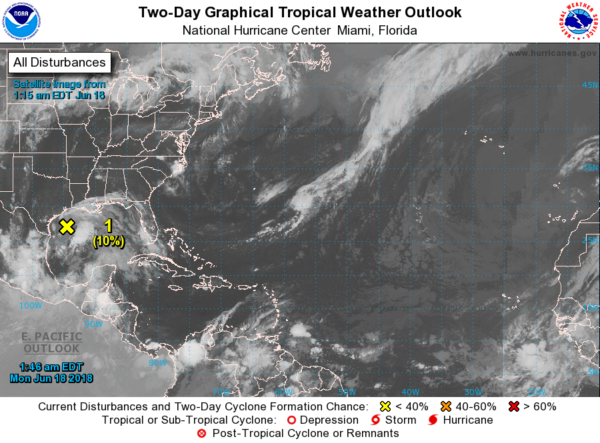
The Atlantic Basin is relatively quiet with the area of disturbed weather in the Northwest Gulf the only concern. Conditions are not favorable for any additional development, but this area will bring 10 to 20 inches of rain to the Texas coast from Victoria to Corpus Christi over the next five days.
Aloft, we have ridging over the eastern portion of the US and the Southeast US through Wednesday, but a strong trough coming out of the northern Rockies is expected to knock down the strength of the ridge beginning on Wednesday and continuing Thursday. Precipitable water values are forecast to stay around 1.6 to 1.8 inches for the next two days so we should see afternoon and evening showers and thunderstorms with highs in the lower 90s. But precipitable water values climb to and slightly above 2 inches late Wednesday and Thursday, so I expect to see showers and storms become more numerous those two days, especially Thursday. The added coverage of storms along with more clouds should keep highs in the upper 80s on Thursday.
That upper trough moves by and weakens from Friday into the weekend, so Friday and Saturday should return to scattered storms mainly in the afternoon and evening hours with highs pushing back up into the lower 90s. By Sunday and Monday, we see weak ridging along the Mississippi River, and the air mass remains fairly wet with precipitable water values once again pushing the 2 inch mark. Highs will be in the range of 88 to 92 across Central Alabama, just a little warmer than the 30-year averages. Lows for the week ahead will be mainly in the lower half of the 70s.
Rainfall for the next five days through Saturday morning will be spotty due to the nature of showers. Places that due get rain could see amounts from one half to one inch.
Looking out into voodoo country, the GFS maintains a bit of troughiness over the eastern half of the country while weak ridging is maintained over the Southeast US. Once again there is no air mass change so we are not likely to see any appreciable change to the weather through the first of July. As we enter July, the GFS becomes bullish on strengthening the ridge over the Central US keeping Alabama on the eastern side of it and out of any terribly excessive heat while the Central US will once again be very warm.
BEACH FORECAST: No affects from the Gulf system or Bud on the beautfiul beaches of Alabama and Northwest Florida. Click here to see the AlabamaWx Beach Forecast Center page.
WEATHERBRAINS: Don’t forget you can listen to our weekly 90 minute netcast anytime on the web, or on iTunes. This is the show all about weather featuring many familiar voices, including our meteorologists here at ABC 33/40.
The Weather Xtreme Video will be on a one-a-day schedule this week as James takes a well earned vacation. I committed to working with the folks at Mercedes Benz plant in Vance for a two-day safety fair, today and Tuesday. I have to be there early to cover folks coming and going on the various shifts, so I don’t expect to have a video tomorrow either. I should have on on Wednesday. Enjoy the day. Godspeed.
-Brian-
.
Category: Alabama's Weather, ALL POSTS


