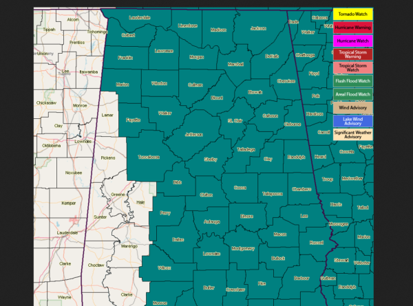
Flash Flood Watch Has Been Expanded For Central Alabama
With the possibility of heavy tropical rain falling farther west on Alberto’s forecast track through Central Alabama, NWS Birmingham has extended the Flash Flood Watch to include Fayette, Marion, Tuscaloosa, Walker, and Winston counties.
The Flash Flood Watch in Central Alabama is set to expire at 7:00 PM Tuesday evening.
NWS Huntsville continues a Flash Flood Watch until 7:00 AM Wednesday morning for Colbert, Cullman, DeKalb, Franklin, Jackson, Lauderdale, Lawrence, Limestone, Madison, Marshall, and Morgan counties.
Here is the text from NWS Birmingham…
…HEAVY RAINS ASSOCIATED WITH THE REMNANTS OF ALBERTO MAY
PRODUCE FLOODING ACROSS PORTION OF CENTRAL ALABAMA…
…FLASH FLOOD WATCH IN EFFECT THROUGH THIS EVENING…
The National Weather Service in Birmingham has expanded the
* Flash Flood Watch to include portions of central Alabama,
northwest Alabama, and west central Alabama, including the
following areas, in central Alabama, Walker. In northwest
Alabama, Marion and Winston. In west central Alabama, Fayette
and Tuscaloosa.
* Through this evening
* Heavy rains of 2 to 4 inches with locally higher totals. The
highest totals will likely be along the Interstate 65 and
Interstate 22 corridors.
PRECAUTIONARY/PREPAREDNESS ACTIONS…
A Flash Flood Watch means that conditions may develop that lead
to flash flooding. Flash flooding is a very dangerous situation.
You should monitor later forecasts and be prepared to take action
should Flash Flood Warnings be issued.
Category: Alabama's Weather, ALL POSTS


