It’s High Noon On Friday And The Weather Is Great Across Central Alabama
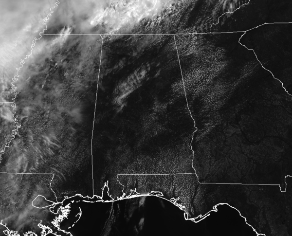
We currently have mostly sunny skies across Central Alabama as we have reach the noon hour on the final day of the work week. All dry at this point and we shall remain that way throughout the remainder of the day and into the evening and late night hours. Showers and thunderstorms will become possible in the northwestern locations of Central Alabama by the early morning hours on Saturday. Temperatures at this time are running in the upper 70s to the lower 80s from north to south, and should reach the mid to upper 80s throughout the area. A few spots in the extreme southeastern parts of the area could touch 90 degrees before the end of the afternoon hours. Clouds will continue to increase from the northwest throughout the afternoon and through the remainder of the day, and lows tonight will reach the lower to mid-60s.
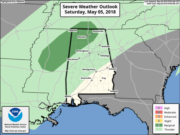
A weak cold front will work through the northern parts of Central Alabama on Saturday, bringing with it a chance of scattered showers and thunderstorms. The good news is that the showers and storms will be diminishing as they move through the northwestern parts of the area and much of the eastern and southeastern parts of the area will stay dry. A few stronger to marginally severe storms are possible in the northwestern parts of the area, including locations in Lamar, Fayette, Marion, Winston, Cullman, and Walker counties. The main threats for these storms will be gusty winds. Tornado and hail threats are very low, but not absolute zero. Remember, we are still in our spring severe weather season, so we have to watch every system that rolls through.
It will not rain all day in the locations that do receive rain. Like I stated earlier, some locations in the south and in the east will stay dry. Much of the southern parts of the area will be mostly clear throughout the day, while partly to mostly cloudy skies can be expected for the northern half of the area. Afternoon highs will be in the upper 70s in the northwest to the upper 80s in the southeast. There could be a few showers left over in the eastern parts of the area by nightfall, but much of the area will be rain-free. We’ll have partly to mostly cloudy skies throughout the night, and lows drop into the mid-50s to the lower 60s.
On This Day In Weather History
1989 – Thunderstorms produced severe weather in the Southern Plains Region and the Lower Mississippi Valley. Thunderstorms spawned fifteen tornadoes, and there were 340 reports of large hail and damaging winds. Hail three inches in diameter, and 9.39 inches of rain, resulted in more than 130 million dollars damage at Monroe LA. Thunderstorm winds gusted to 100 mph at Epps LA and Fort Worth TX. A thunderstorm north of Mineral Wells TX produced high winds which unroofed a nightclub, turning it into a “topless club.”
Beach Forecast Center
Don’t you wish you were there, already? Soaking up the rays and wiggling your toes in the sand? Get the latest weather and rip current forecasts for the beaches from Fort Morgan to Panama City on our Beach Forecast Center page. There, you can select the forecast of the region that you are interested in.
WeatherBrains
Don’t forget you can listen to our weekly 90 minute netcast anytime on the web at WeatherBrains.com or on iTunes. This is the show all about weather featuring many familiar voices, including the meteorologists at ABC 33/40.
E-Forecast
Get the AlabamaWx Weather Blog’s Seven-Day Forecast delivered directly to your inbox by email twice daily. It is the most detailed weather forecast available in Central Alabama. Subscribe here… It’s free!
Advertise With Us
Don’t miss out! We have enjoyed nearly 8.4 MILLION page views on AlabamaWx.com since the start of 2018. We can customize a creative, flexible and affordable package that will suit your organization’s needs. Contact Bill Murray at (205) 687-0782.
Category: Alabama's Weather, ALL POSTS


