Showers Today; Stronger Storms Tonight
RADAR CHECK: Showers have formed ahead of schedule across Alabama early this morning; they are moving eastward across the state at daybreak. Today will be cloudy with a warmer afternoon; most communities reach the low 70s later today. We will maintain the chance of showers during the day, but heavier storms will arrive tonight. SPC maintains a “slight risk” of severe storms for the western side of the state, in the broad region from Fayette to Citronelle. A “marginal risk” extends as far east as Steele, Talladega, and Troy.
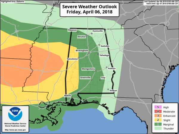
There is very limited surface based instability available for North Alabama… sure looks like the core severe threat will be over the southern half of the state.
TIMING: The window for the heavier storms will come from 10:00 tonight through 7:00 a.m. tomorrow for Central Alabama.
THREATS: The main issue will be strong, gusty straight line winds. An isolated, short lived tornado is not out of the question, mainly over Southwest Alabama. Some small hail is possible as well in the heavier thunderstorms.
RAIN: Rain amounts of 1/2 to 1 inch look likely, not enough for any flooding problems.
Bottom line is that is a pretty low end severe weather threat for Central Alabama, but as always, with thunderstorms you have to expect the unexpected, so we will keep a close eye on radar trends overnight.
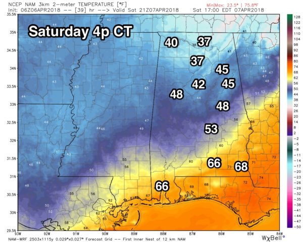
COLD, RAW DAY TOMORROW: Rain will taper off early tomorrow morning, but the day will be cloudy, windy, and cold with temperatures falling through the 50s, reaching the 40s during the afternoon. The high resolution NAM model even hints some North Alabama communities might be in the 30s…
Some patchy light rain or drizzle is also possible during the day. It sure won’t feel like spring; these temperatures are 30 degrees below average for early April in Alabama.
FREEZE WATCH SUNDAY MORNING: A freeze is a good possibility by daybreak Sunday as the sky becomes clear and the winds drops to near calm. We are expecting lows in the low 30s for most North/Central Alabama communities; colder pockets will visit the 20s. Then, during the day Sunday, the sky will be sunny with a high in the mid 60s.
FOOTBALL WEATHER: For Auburn’s A-Day game tomorrow at Jordan Hare Stadium (3:00p CT kickoff)… the weather will be cloudy, breezy, and cold with temperatures falling from the mid 50s at kickoff, into the 40s during the second half. A brisk northwest wind of 10-20 mph will make it feel colder.
NEXT WEEK: Some rain is possible late Monday, Monday night, and possibly into part of the day Tuesday, followed by another shot of colder air. Output from global model ensembles continues to suggest we could see some frost early Wednesday morning with a low in the mid 30s; a decent chance this will be the last frost threat of the season for most of the state. See the Weather Xtreme video for maps, graphics, and more details.

BEACH FORECAST: Click here to see the AlabamaWx Beach Forecast Center page.
WEATHER BRAINS: Don’t forget you can listen to our weekly 90 minute netcast anytime on the web, or on iTunes. This is the show all about weather featuring many familiar voices, including our meteorologists here at ABC 33/40.
CONNECT: You can find me on all of the major social networks…
Facebook
Twitter
Google Plus
Instagram
Pinterest
Snapchat: spannwx
I will be speaking this morning at a special ceremony at Oak Grove High School to commemorate the 20th anniversary of the April 8, 1998 EF-5 tornado that killed 32 people in the western part of the Birmingham metro area… then I have a weather program at Greystone Elementary in Hoover. Look for the next Weather Xtreme video here by 4:00 this afternoon. Enjoy the day!
Category: Alabama's Weather, ALL POSTS, Weather Xtreme Videos
About the Author (Author Profile)
James Spann is one of the most recognized and trusted television meteorologists in the industry. He holds the AMS CCM designation and television seals from the AMS and NWA. He is a past winner of the Broadcast Meteorologist of the Year from both professional organizations.Subscribe
If you enjoyed this article, subscribe to receive more just like it.


