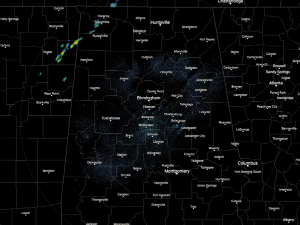
A Pretty Nice Day Across Central Alabama At Midday; Storms Move In Late Tonight
Conditions at 12:30 PM
As we have reached the middle of the midday hour, a few showers have started moving into the northwestern parts of the state but is currently still north of the Central Alabama area. Skies are mostly cloudy in the western parts of the area, while much of the east is enjoying mostly clear skies. Nice and mild temperatures are being felt across the area, ranging from the mid 60s in the north to the upper 70s in the south. Cullman is the cool spot at 66 degrees, while Montgomery and Eufaula are tied as the warm spots at 77 degrees. Birmingham is sitting at 75 degrees.
Weather For The Rest Of Your Wednesday
A slight risk of scattered showers and maybe a thunderstorm or two will be possible over the northwestern quarter of Central Alabama throughout the remainder of the afternoon. Those risks will continue to rise over the evening and become likely during the late night and overnight hours as the rain and thunderstorms slowly move eastward. There is a Marginal Risk for severe storms has been defined for the northwestern corner of the state, but at this point the threat is very low with gusty winds being the main threat. For the remainder of Central Alabama, the risk for any showers or storms will be very low closest to I-59 and I-20/59 while the east and southeastern parts of the area staying dry. Today’s highs will be quite mild to warm, reaching the upper 70s to the lower 80s from north to south. Lows tonight will be in the upper 50s to the mid-60s.
Severe Weather Potential On Thursday
This is the latest Day 2 Outlook from the Storm Prediction Center, but I believe the Slight Risk (level 2 of 5) will be expanded eastward some, as models are showing backed surface winds along with higher surface-based instability values making it along and east of I-65. This, along with 0-1km shear values of 30-40 kts, could bring a slightly higher risk of supercells and tornadoes to the area.
Timing for the greatest risk of stronger to severe storms will start around the 10:00 AM – 2:00 PM time frame for the western sections of the area (along and west of a line from Cordova to Brookwood to Uniontown), making it into the central parts of the area around 12:00 PM – 4:00 PM (along and west of a line from Sand Rock to Talladega to Fort Deposit), and into the eastern parts of the area around 2:00 PM to 7:00 PM (areas stretching east of a line from Sand Rock to Talladega to Fort Deposit to the Georgia state line).
At this point, damaging winds and a few tornadoes are possible in the areas defined in the Slight Risk, while those same threats are possible but are less likely in the areas defined in the Marginal Risk.
The good news is that this system will be nothing like the one that affected the state back on March 19th, but with any storm system that moves through Central Alabama during the middle of our main severe weather season, it will bear watching. No need to be fearful… As long as you are prepared for severe weather by having your safety kits and plans ready to go, along with fresh batteries in your flashlights and radios, you should be good to go. We’ll keep you covered on the blog with frequent updates throughout the day.
Highs on Thursday will be in the upper 60s in the northwest to the lower 80s in the southeast. Rainfall totals will be around 1.00″ for much of Central Alabama with totals approaching 2.00″ in the northwest corner of the area. Up in North Alabama, an Areal Flood Watch goes into effect for Colbert, Franklin, and Lauderdale counties starting at 7:00 PM tonight and goes until 7:00 PM Thursday night, where rainfall totals will range from 2-3 inches with locally higher amounts possible.
The good news is that we’ll begin to dry out during the overnight hours, setting us up for a decent Easter weekend in Central Alabama. Skies will become partly cloudy before sunrise on Friday, and lows will bottom out in the upper 40s to the upper 50s.
Beach Forecast Center
Don’t you wish you were there, already? Soaking up the rays and wiggling your toes in the sand? Get the latest weather and rip current forecasts for the beaches from Fort Morgan to Panama City on our Beach Forecast Center page. There, you can select the forecast of the region that you are interested in.
WeatherBrains
Don’t forget you can listen to our weekly 90 minute netcast anytime on the web at WeatherBrains.com or on iTunes. This is the show all about weather featuring many familiar voices, including the meteorologists at ABC 33/40.
E-Forecast
Get the AlabamaWx Weather Blog’s Seven-Day Forecast delivered directly to your inbox by email twice daily. It is the most detailed weather forecast available in Central Alabama. Subscribe here… It’s free!
Advertise With Us
Don’t miss out! We have enjoyed more than 5.8 MILLION page views on AlabamaWx.com since the start of 2018. We can customize a creative, flexible and affordable package that will suit your organization’s needs. Contact Bill Murray at (205) 687-0782.
On This Day In Weather History
1984 – A violent outbreak of tornadoes hit the Carolinas. Thunderstorms spawned 22 tornadoes during the late afternoon and evening hours which killed 57 persons and injured 1248 others. Nearly half the deaths occurred in mobile homes. A tornado from near Tatum SC to southern Cumberland County NC was 2.5 miles in width at times.
Category: Alabama's Weather, ALL POSTS


