8:30 p.m. Update on the Alabama Weather Situation
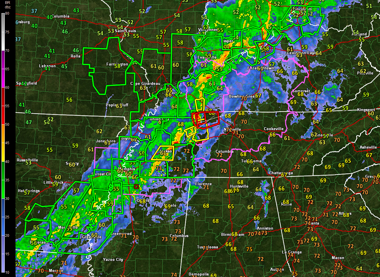
An amazing note tonight: You can drive from Camden, Arkansas all the way to Cincinnati, Ohio and never level a flash flood warning polygon.
Flash flooding is no expected to be a problem in Alabama tonight, and the severe weather threat continues to diminish.
Our line of thunderstorms has passed Memphis tonight. It is about 95 miles west of the Northwest Corner of Alabama. At its current rate of motion, east at about 35 mph, it will reach the Quad Cities of Muscle Shoals, Florence, Sheffield and Tuscumbia around 11-11:30 p.m.
The severe weather threat is primarily north of I-40 in Tennessee, between Memphis and Nashville, into southern Kentucky. There are still several tornado warnings in effect in northwestern Tennessee and southern Kentucky. The most dangerous storms are approaching Dover, TN and will affect Clarksville within the next 90 minutes.
A tornado watch remains in effect until 9 p.m. for eastern Arkansas, northern Mississippi, western Tennessee, southern Illinois and western Kentucky. The thinking is that this watch will not be extended to the southeast. A new tornado watch has been issued for Central Tennessee and southern Kentucky.
That is because the severe weather threat over northern Mississippi and North and Central Alabama is diminishing. The airmass has become fairly stable in all but a couple of small pockets over northeastern and West Central Mississippi. In fact, convective inhibition is now the rule over much of North and Central Alabama.
The low-level jet is lifting into northwestern Tennessee and western Kentucky, explaining the remaining severe weather threat there.
The weakening line of storms should reach Northwest Alabama by 10-11 p.m., Hamilton by midnight, Jasper by 2 a.m., Tuscaloosa/Birmingham/Gadsden by 3-4 a.m. and Clanton and Anniston by 5 a.m. It will reach the I-85 corridor by 8-9 a.m.
There is a small threat of a damaging wind gust or two, but most wind gusts will be in the 25-35 mph category.
The frontal system will stall near I-85 tomorrow morning. Another couple of rounds of showers and storms will overspread Central Alabama during the afternoon and overnight hours tomorrow, finally pushing out of the area Monday morning. Severe weather is possible tomorrow in places like Gadsden, Birmingham, Anniston, Chilton, Montgomery, Auburn, Greenville and Mobile.
Category: Alabama's Weather, ALL POSTS
About the Author (Author Profile)
Bill Murray is the President of The Weather Factory. He is the site's official weather historian and a weekend forecaster. He also anchors the site's severe weather coverage. Bill Murray is the proud holder of National Weather Association Digital Seal #0001 @wxhistorianSubscribe
If you enjoyed this article, subscribe to receive more just like it.


