Rain Moving Out but Cold Sticks Around
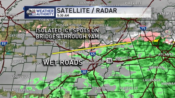
The hardest Weather Xtreme Videos to do are when the weather is going on during preparation of the videos because it is so hard to keep up with the rapid changes. Generally at this writing, the biggest area for an icing threat with light winter precipitation falling was north of a line from about Jasper in Walker County to Gadsden in Etowah County – see graphic below.
Pretty much in line with the forecast, overrunning began across southern Alabama yesterday evening and spread rapidly east. But by 10 pm or so, precipitation had also spread northward. I recorded only 4 hundredths of an inch of rain before midnight. Fortunately the greatest threat for winter weather along with the biggest potential for any impact was across the extreme northern sections of Central Alabama north of about Warrior. This morning around sunrise temperatures were still sticking right around the freezing mark across the Tennessee River Valley with above freezing temperatures south of a line from Japser to Gadsden. Precipitation will continue to move eastward fairly rapidly for North and Central Alabama while rain remains a possibility across South Alabama.
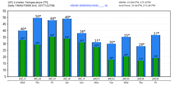
Our upper air pattern remains locked in a cold one with the broad trough situated over the eastern two-thirds of the US. The trough axis for the broad trough was from Lake Michigan to the Lower Mississippi River Valley. The broad trough will remain locked in place with only a small shift of the major axis to the east over the next several days through Saturday. This will keep us cold but dry. Morning lows will be at or just below freezing with afternoon highs in the 40s but possibly edging into the lower 50s for each day into Saturday.
The big show is coming for New Year’s Eve and New Year’s Day. Unfortunately the European Weather Center experienced a power outage earlier today, so we have no ECMWF forecasts covering this period. And the GFS seems to remain bullish on the idea of winter weather across the northern half of Alabama.
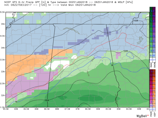
Sunday a strong upper trough is forecast to develop from the Great Lakes westward to Wyoming and swing rapidly southeast through the broad trough. This will bring a monstrous surface high forecast to be 1056 millibars into eastern Montana. To the south, the GFS is picking up on overrunning precipitation across the Lower Mississippi River Valley. With cold air in place, the GFS is painting a large swath of winter precipitation – that is, sleet, freezing rain, and snow – from Northeast Texas to Northwest Alabama. By midnight on Sunday, the GFS has a surface low in the Gulf just south of Mobile and New Orleans. This pattern, if it verifies, certainly supports the idea of a wintery mess to end 2017 and start 2018.
By New Year’s Day afternoon, the precipitation is coming to an end for Alabama but temperatures are projected to be below 30 degrees from Birmingham northward. GFS MOS guidance prints out lows in the teens for Birmingham for the 1st, 2nd, and 3rd of January while highs struggle to get much higher than the upper 30s. In other words, it’s going to be downright cold to start the new year. The overall issue with the whole winter precipitation event is that the GFS has been more bullish on being wet while the ECMWF has been drier. And the ensembles out of the GFS continued to show a large variation, so we’re going to have to rely on future runs to hone the forecast for this event.
Looking into voodoo country, another cold shot is forecast to come at us on the 4th of January with another strong trough coming through the broad trough across the East. But hold on, there is some hope for slightly warmer conditions. The flow is forecast to go nearly zonal around the 6th to give us a couple of warmer days. But the warmer weather does not last long with another strong trough digging the broad trough back into the eastern US on the 8th of January. The train continues into the 9th and 11th of January with a continuous stream of short waves coming through the flow giving us little relief from the overall cold pattern.
Both Auburn and Alabama will be playing inside enclosed stadiums, so there is no worry about the weather during the games. But getting there and home may see some issues. For those headed to Atlanta for the Peach Bowl with Auburn facing the UCF Knights with an 11:45 am CST kickoff, New Year’s Eve will be cold with a high of only 38 along with the potential for snow and sleet. Game day will also be cold with a slight chance of rain and snow and a high of only 38.
For the Sugar Bowl in New Orleans where Alabama and Clemson face-off at 7:45 pm CST, there will be a chance for rain for New Year’s Eve with a high of 51. New Year’s Day should also see some chance for rain with a high around 44.
Beach Forecast: Click here to see the AlabamaWx Beach Forecast Center page. The Beach Forecast is partially underwritten by the support of Brett/Robinson Vacation Rentals in Gulf Shores and Orange Beach. Click here to see Brett/Robinson’s Hot Deals now!
WeatherBrains: Don’t forget you can listen to our weekly 90 minute netcast anytime on the web, or on iTunes. This is the show all about weather featuring many familiar voices, including our meteorologists here at ABC 33/40.
I will be monitoring the latest model runs and I expect to post the next Weather Xtreme Video here around 7 am or so on Thursday. Stay dry and warm today. Godspeed.
-Brian-
Category: Alabama's Weather, ALL POSTS, Weather Xtreme Videos


