Mild Week; Wet/Stormy At Times
DENSE FOG ADVISORY: We have dense fog and drizzle across most of Alabama early this morning; a Dense Fog Advisory is in effect though mid-morning. A warm front is draped across the southern part of the state; temperatures are in the mid to upper 60s south of the front, and in the cool 40s north of the boundary.
The warm front will move northward today, and by afternoon most of the state will be in the 60s. The sky will remain cloudy, and a few scattered showers are possible. Nothing too heavy or widespread.
TOMORROW/WEDNESDAY: A wave will form on the front west of Alabama, and rain will increase late in the day tomorrow, tomorrow night, and into Wednesday. The rain will be heavy at times over North Alabama, and some flash flooding is possible over the Tennessee Valley, where rain amounts could exceed 3-4 inches. Rain totals for places like Tuscaloosa, Birmingham, Anniston, and Gadsden should be in the 1-2 inch range.
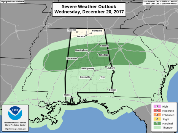
We should also mention that a few strong to severe storms are possible Wednesday as the air will be relatively unstable; SPC has a “marginal risk” of severe storms defined for the I-20 corridor.
Some of the storms Wednesday could produce strong winds, and a brief tornado or two can’t be ruled out. For now it seems like the main threat will come during the morning hours, generally between 3 and 10 a.m.
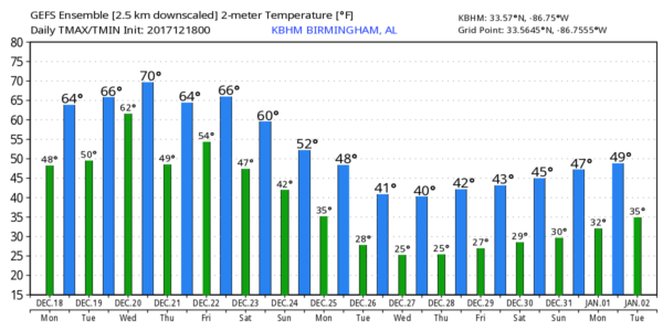
Temperatures will be mild tomorrow and Wednesday with highs in the mid to upper 60s. We could see low to mid 70s over South Alabama Wednesday.
THURSDAY/FRIDAY: For now Thursday looks mostly dry with some sun possible; the weather stays mild with highs in the 60s. Then, on Friday, we will bring back a chance of rain with the approach of a cold front. The high Friday should be well into the 60s.
SATURDAY/SUNDAY: Forecast confidence is not especially high due to wildly varying global computer model output and a complex pattern. For now, we will forecast mostly cloudy weather Saturday and Sunday with some risk of rain both days; temperatures will be a big forecast challenge with a well defined front hanging around North Alabama. There is a decent chance Saturday will be cooler with a high in the 50s, but the front could lift northward Sunday, and there is some potential that mild air will be pulled northward again into the northern half of the state.
For now, we will forecast highs in the 50s both days, but be aware this could change.
CHRISTMAS DAY: Deterministic model output over the last few days has suggested Christmas Day could be warm, cold, wet, or dry. Take your pick. No doubt we need to use the ensemble approach, which suggests the day will be cold and dry for much of the state, although there is potential for a tight thermal gradient somewhere over South Alabama. But again, for now, we will forecast cold, dry weather Monday for the northern half of the state with highs in the 40s.
THE DAYS AFTER CHRISTMAS: There is good agreement that very cold air will settle into Alabama by the middle of next week. And, just for the fun of it, we are seeing signs of potential winter “mischief” by mid-week with some risk of freezing or frozen precipitation across parts of the Deep South as a southwest flow aloft develops over the cold air. No way to be specific, but the idea is clearly on the table… see the Weather Xtreme video for maps, graphics, and more details. Many will be traveling and you will want to keep an eye on the forecast.
BEACH FORECAST: Click here to see the AlabamaWx Beach Forecast Center page. The Beach Forecast is partially underwritten by the support of Brett/Robinson Vacation Rentals in Gulf Shores and Orange Beach. Click here to see Brett/Robinson’s Hot Deals now!
WEATHER BRAINS: Don’t forget you can listen to our weekly 90 minute netcast anytime on the web, or on iTunes. This is the show all about weather featuring many familiar voices, including our meteorologists here at ABC 33/40.
CONNECT: You can find me on all of the major social networks…
Facebook
Twitter
Google Plus
Instagram
Pinterest
Snapchat: spannwx
I have a weather program this morning at Mountain Brook Elementary School… look for the next Weather Xtreme video here by 4:00 this afternoon. Enjoy the day!
Category: Alabama's Weather, ALL POSTS, Weather Xtreme Videos


