Some Snow Possible Tomorrow Across Central Alabama
COLD, CLOUDY DAY: Temperatures this morning are mostly in the 37-42 degree range across North/Central Alabama, and today will be another overcast day with a touch of light drizzle possible in spots; most of the rain will fall over the southern half of the state. And, like yesterday, we won’t get out of the 40s.
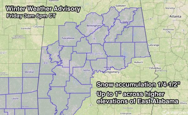
WINTER WEATHER MISCHIEF TOMORROW: With the upper trough approaching tomorrow, precipitation will increase over the southern two-thirds of the state, and cold, Arctic air will creep in from the north. This combination will bring thermal profiles favorable for some snow across parts of Central and Southwest Alabama, and NWS offices in Birmingham and Mobile have issued a Winter Weather Advisory for this region…
TIMING: Precipitation in the form of rain or snow will begin during the pre-dawn hours tomorrow; the main chance of seeing snow flakes will come from 3:00 a.m. until 3:00 p.m.
PLACEMENT: The north edge of the precipitation shield will be near I-20, or along a line from York to Eutaw to Tuscaloosa to Birmingham to Oxford to Heflin. Some snow is possible far south as a line from Jackson to Camden to Selma to Montgomery to Dadeville and Lafayette.
ACCUMULATION POTENTIAL: Within the advisory, some places (not all) will see 1/4 to 1/2″ of snow, mostly on grassy areas. Amounts to 1″ are possible across higher terrain of East Alabama. Accumulation will be limited by warm soil temperatures.
IMPACT: Temperatures early tomorrow will be in the 30-35 degree range. While most roads will be just wet, it is very possible there could be some icy spots. I would get up extra early tomorrow and check on road conditions before leaving.
Midday temperatures should rise into the mid to upper 30s, so conditions should improve by then. However, any lingering water on the roads tomorrow night could freeze again as temperatures drop down into the 20s. Those icy patches could linger into Saturday morning.
IMPORTANT POINTS: Please note…
*Not everyone in the Winter Weather Advisory will see snow. Some on the northern periphery could very well see no precipitation at all, and others on the southern side could see just rain, or a rain/snow mix.
*With almost every winter weather event in Alabama, there is a surprise or two. Watch for last minute forecast changes; if you are using an old forecast (more than 6 hours old), it is bad information.
*Will this be another “Snowmageddon”? No, because surface temperatures this time will be 10-15 degrees warmer at the surface. During the January 2014 snow event, temperatures were in the 17-21 degree range when the snow was falling, and the ice accretion process on roads is radically different when it is that cold (we all learned the hard way!).
*North Alabama will be totally dry tomorrow (north of I-20)… and cold.
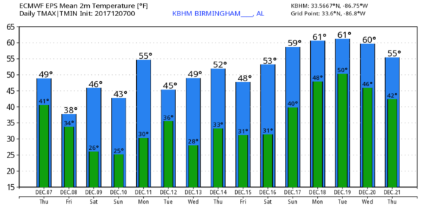
THE ALABAMA WEEKEND: Dry, cold weather is the story with mostly sunny days and fair nights. Highs mostly in the 40s, lows mostly in the 20s. Colder pockets will see upper teens early Sunday morning.
NEXT WEEK: The pattern looks dry with temperatures remaining below average; we should rise into the 50s Monday, but a new surge of colder air arrives Tuesday.
BEACH FORECAST: Click here to see the AlabamaWx Beach Forecast Center page. The Beach Forecast is partially underwritten by the support of Brett/Robinson Vacation Rentals in Gulf Shores and Orange Beach. Click here to see Brett/Robinson’s Hot Deals now!
WEATHER BRAINS: Don’t forget you can listen to our weekly 90 minute netcast anytime on the web, or on iTunes. This is the show all about weather featuring many familiar voices, including our meteorologists here at ABC 33/40.
CONNECT: You can find me on all of the major social networks…
Facebook
Twitter
Google Plus
Instagram
Pinterest
Snapchat: spannwx
I have a weather program this morning at Marion County Christian Academy… look for the next Weather Xtreme video here by 4:00 this afternoon. Enjoy the day!
Category: Alabama's Weather, ALL POSTS, Weather Xtreme Videos


