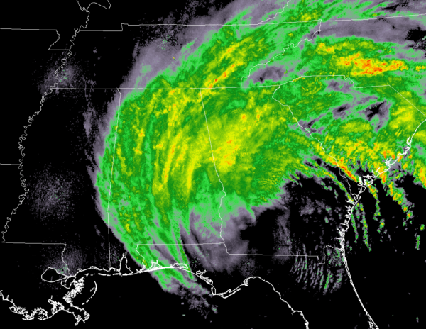
3:10 PM Monday Check On Central Alabama’s Weather
They say that the western side of a hurricane or tropical storm is usually it’s “dry side.” Well, it hasn’t been dry across Central Alabama throughout the day today, and it probably will remain pretty wet throughout the remainder of the evening and into the late night and overnight hours.
Even though rain has been falling for a good part of the day, totals are not all that impressive at this time for most across the area. Estimates at this point range from 0.12 inches at Tuscaloosa to 0.42 inches in Birmingham to 1.13 inches in Alexander City. At this point, the highest estimated rainfall total is at Eufaula with 2.73 inches. All of these estimated totals were as of 3:00 PM CDT.
Tropical Storm Warning remains in effect until further notice for much of the eastern half of Central Alabama including Barbour, Blount, Bullock, Calhoun, Chambers, Cherokee, Clay, Cleburne, Coosa, Elmore, Etowah, Lee, Macon, Montgomery, Pike, Randolph, Russell, St. Clair, Talladega, and Tallapoosa counties.
Wind Advisory remains in effect until 1:00 AM CDT on Tuesday for the western half of Central Alabama including Autauga, Bibb, Chilton, Dallas, Fayette, Greene, Hale, Jefferson, Lamar, Lowndes, Marengo, Marion, Perry, Pickens, Shelby, Sumter, Tuscaloosa, Walker, and Winston counties.
We are still getting several damage reports in from the east and southeastern parts of Central Alabama, mainly from downed trees and power outages. We’re hoping that this trend doesn’t continue westwardly into the rest of the area, but it doesn’t look like Irma is going to cooperate with us too well. Alabama Power is now reporting that 45,000 customers are without power at this point.
We are still expecting the sustained winds to pick up later on this afternoon and into the evening hours, up to 25-40 MPH for most in the eastern half of the area. Gusts of 50 MPH will be possible as well. For the western half of the state, the stronger winds will arrive later during the evening to the overnight hours. Winds of 15-30 MPH can be expected, with gusts up to 40 MPH possible.
As the center of Irma moves closer to the state and eventually into Central Alabama, rainfall totals will go up in number. Latest estimates show a range of 1-2 inches for the extreme western parts of the area, with 2-3 inches possible for the central parts, and 3-4 inches possible for the eastern parts.
Temperatures will remain very cool throughout the remainder of the day and into the night time hours. Highs are only expected to be in the lower 60s to near 70 degrees throughout the area, and dropping into the upper 50s to the lower 60s for tonight’s lows.
Latest run of the NAM-3k model shows much of the heavier rain will push over into northern parts of Mississippi by rush hour tomorrow morning, and only scattered showers will be possible throughout the northern half of Central Alabama throughout the rest of your Tuesday. Winds throughout the daylight hours will have dropped and the highest gusts will be less than 30 MPH throughout the area. Much of the northern parts of Central Alabama will stay cloudy throughout the day, but some clearing is possible late in the day in the southern parts. Tomorrow’s highs will be in the mid-60s to the mid-70s from north to south.
Category: Alabama's Weather, ALL POSTS


