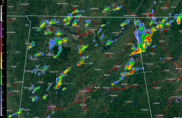
1 p.m. Radar Update

Storms continue over North and North Central Alabama this afternoon south of a slowly sagging front and east of an upper level trough.
A disturbance is moving through northern Mississippi at this hour, causing storms to pulse up over areas west of I-65 and north of I-20.
One strong storm moved through Fayette County but has been weakening as it moves into Walker County. A new storm north of Jasper and another just south of Cullman have become dominant in this area. Lots of lightning and heavy rain. Winds will be gusty as well, although not to severe limits yet.
Remember that 40-50 mph winds will be able to bring down trees today given our saturated soil conditions.
In East Alabama, intense heating has created an axis of instability. CAPE values have been over 4,000 joules/kg in spots. The storm over northern Cherokee County was previously severe, downing some trees near Fyffe as it collapsed. Strong storms now extend from Piedmont to Jacksonville in Calhoun County and also are near Gaylesville and Cedar Bluff in Cherokee County, southeast of Little River Canyon.
The Tuscaloosa and Birmingham areas are calm for now, with nothing upstream. The activity to the west should rotate in to the Birmingham area during the afternoon.
Category: Alabama's Weather, ALL POSTS


