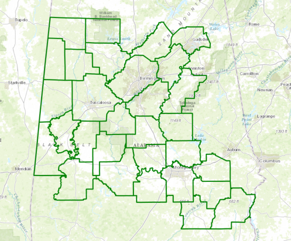
Flash Flood Watch For Much Of Central Has Been Extended Until 7PM Friday
URGENT – IMMEDIATE BROADCAST REQUESTED
Flood Watch
National Weather Service Birmingham AL
536 PM CDT Thu Jun 22 2017
ALZ014-017-018-026-027-231200-
/O.EXB.KBMX.FF.A.0003.000000T0000Z-170624T0000Z/
/00000.0.ER.000000T0000Z.000000T0000Z.000000T0000Z.OO/
Winston-Blount-Etowah-St. Clair-Talladega-
Including the cities of Double Springs, Oneonta, Gadsden,
Pell City, Moody, Talladega, and Sylacauga
536 PM CDT Thu Jun 22 2017
…FLASH FLOOD WATCH IN EFFECT THROUGH FRIDAY EVENING…
The National Weather Service in Birmingham has expanded the
* Flash Flood Watch has been expanded in time and location.
* Through early Friday evening.
* Moderate to heavy rains will relax across the area tonight, but
will quickly redevelop Friday. Tropical system Cindy has already
dumped 2 to 4 inches of rain with locally higher amounts up to 6
inches. An additional 2 inches of rain or so is possible Friday
into Saturday.
PRECAUTIONARY/PREPAREDNESS ACTIONS…
A Flash Flood Watch means that conditions may develop that lead
to flash flooding. Flash flooding is a very dangerous situation.
You should monitor later forecasts and be prepared to take action
should Flash Flood Warnings be issued.
&&
$$
ALZ011>013-015-022>025-030>036-039-231200-
/O.EXT.KBMX.FF.A.0003.000000T0000Z-170624T0000Z/
/00000.0.ER.000000T0000Z.000000T0000Z.000000T0000Z.OO/
Marion-Lamar-Fayette-Walker-Pickens-Tuscaloosa-Jefferson-Shelby-
Sumter-Greene-Hale-Perry-Bibb-Chilton-Coosa-Marengo-
Including the cities of Hamilton, Sulligent, Vernon, Fayette,
Jasper, Carrollton, Tuscaloosa, Birmingham, Hoover, Columbiana,
Pelham, Alabaster, Livingston, Eutaw, Greensboro, Moundville,
Marion, Centreville, Clanton, Rockford, Demopolis, and Linden
536 PM CDT Thu Jun 22 2017
…FLASH FLOOD WATCH NOW IN EFFECT THROUGH FRIDAY EVENING…
The Flash Flood Watch is now in effect for
* Flash Flood Watch has been expanded in time and location.
* Through early Friday evening.
* Moderate to heavy rains will relax across the area tonight, but
will quickly redevelop Friday. Tropical system Cindy has already
dumped 2 to 4 inches of rain with locally higher amounts up to 6
inches. An additional 2 inches of rain or so is passable Friday
into Saturday.
PRECAUTIONARY/PREPAREDNESS ACTIONS…
A Flash Flood Watch means that conditions may develop that lead
to flash flooding. Flash flooding is a very dangerous situation.
You should monitor later forecasts and be prepared to take action
should Flash Flood Warnings be issued.


